The pleasant streets of Grindavik on the southern tip of Iceland are now barren, stark, and cracked, as empty-seeming as the vast landscape around it. On 11 November, this Iclandic fishing town was evacuated on fears of an imminent volcanic eruption.
Just eleven days earlier, at the beginning of the month, Grindavik was bustling in its friendly, small-town way. However, since midsummer here the magma system that fuels the molten pots of nearby Fagradalsfjall and Litli-Hrútur volcanoes, 12 kilometers to the east, has bubbled and quaked. (There was a brief eruption visible by the many hikers who came to visit the area in July.)
The drone that took these images in July (at the Litli-Hrútur volcanic rent) was about 400 meters away from the magma, hovering at some 100 meters altitude.Christopher Hamilton/University of Arizona
At the time of the July activity, the molten rock was in motion. From a twin-engine Dornier airplane, Ralf Horn had a pretty good view of it, but not by sight: he was recording large swaths of Icelandic lava fields illuminated through onboard instruments emitting five separate radar bands. And the view is not just trained on Iceland. The group of researchers Horn is with are preparing for a remote-sensing mission to Venus. They figure the fiery fountains near Grindavik, and in the much more remote northern highlands, make an excellent model for the work they’ll do to understand strange Venusian landscapes and how they came to be such apparent hellfields.
“What we will be able to do will give us an entirely new picture of Venus.”
—Suzanne Smrekar, NASA Jet Propulsion Laboratory
Horn had a handful of colleagues with him on the plane, an aerial radar station operated by the German Aerospace Center (DLR). Scott Hensley, a project scientist with NASA’s Jet Propulsion Laboratory (JPL), was on the ground validating the data as it came down, working with the plane’s crew to prep for the next day’s flights. At the same time JPL geophysicist Suzanne Smrekar was leading a handful of ground research teams: JPL is in charge of preparing for a Venus mission called VERITAS, and Smrekar is its principal investigator.
They say they hope to shake out kinks and hone their analytic techniques for the time when similar radar waves emitted from onboard VERITAS wash through the thick Venusian clouds. The VERITAS radar equipment will light up an alien surface blistering under an average of 464º Celsius (867º Fahrenheit). And so Smrekar, Horn, and their colleagues—Christopher, the drone pilot and planetary volcanologist from Tucson; Gro the local guide and lava expert who lists ‘chaos’ as a root topic of study; other scientists from Italy and Iceland—spent two weeks at the end of July and beginning of August out in the fields.
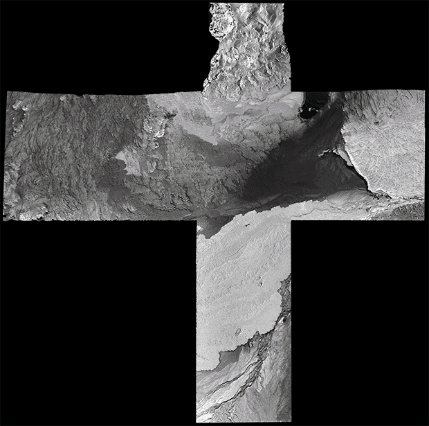 In X-band [black and white] and S-band [colored] radar, Iceland’s Holuhraun lava field gains far more than just a new color palate.German Aerospace Center
There were two prongs to the expedition, over two sites of shattered rock and smooth pools of cast-in-place basalt: some new, some old, forged by rivers of flame. To the southwest, not far from Grindavik and a little south of the capital Reykjavik, is the Fagradalsfjall system. Much more remote to the northern highlands, between milky Lake Askja and titanic ice cap Vatnajökull, is Holuhraun: a lava field most recently altered in 2014 and 2015, when a fissure eruption poured 1.4 cubic kilometers of 1200-degree magma over the surface, sometimes reaching 350 cubic meters per second.
“The human mind is not used to landscapes changing with this speed,” says Gro Birkefeldt Møller Pedersen, a Danish volcanologist based at the University of Iceland who guided the teams through Fagradalsfjall and Holuhraun.
“You come down to the same place and it’s just different,” she says. “Because the lava has advanced 500 meters, and the load of lava is squeezing out water. Suddenly you have water where you did not have water before, because this lava was in place.”
And the story remains written into the roughness and topography of the living rock.
Another view of the Litli-Hrútur volcanic rent, Fagradalsfjall, Iceland from July. Christopher Hamilton/University of Arizona
Ralf Horn and his cohorts in July and August measured a city-sized part of that topography from 19,000 feet in a series of straight-line parallel passes recording data at very high resolution. The DLR Dornier 228-212, which has been flying missions since 2008, is a specialized radar platform: some antennas are mounted on an aerial frame bolted to the side of the aircraft. There’s another on the underside of the plane, just behind the nose wheel.
It’s all part of an airborne synthetic aperture radar unit, or F (for Flugzeuggetragenes) -SAR. First developed for American nuclear missiles in the early 1950s, synthetic aperture radar is an instrument that uses short antennas emitting a sequence of radar waves combined—ergo, synthetic—in order to simulate a much larger antenna. SAR sensors can operate in several wavelengths. The DLR’s small and mighty Dornier is fitted for X, C, S, L and P bands, which all told range from three centimeters up to 69-cm waves. The F-SAR can manage polarimetric imaging in all of these frequencies. Analyzing signal strength from different wave polarization—polarimetric imaging—yields further detail about the structure being illuminated.
Understanding Venus is compelling not just for its own sake, but also because it’s a planet sometimes described as Earth gone very wrong.
It means the sensors are very good for scanning surfaces for structure and moisture and can create 2D and 3D images. The images can reveal interesting and useful things about the composition and shifting topography of the ground surface over time. For example, DLR’s radar plane collected data in the X-band over Fagradalsfjall during its overflights for a specific place and time. This data can be converted into height information.
When the data is compared to a digital surface model of the Earth (the European Space Agency’s Copernicus DEM, first published in 2019), the F-SAR imaging from Fagradalsfjall is able to discern the volume of lava flow from three eruptions in the area: in 2021, 2022, and the newest, in 2023.
That kind of information will be vital for the Venus mission, one of the main goals of which is to map how active the surface of the planet is. Researchers are now further calibrating many terabytes of radar data collected from Fagradalsfjall and Holuhraun.
Just over thirty years ago, the NASA probe Magellan went to Venus, deploying synthetic aperture radar to scan the planet surface. VERITAS would deliver vastly sharper imaging data with its updated SAR. Researchers would also be able to compare Magellan’s S-band data with new X-band data from VERITAS of the same Venusian regions.
“What we will be able to do will give us an entirely new picture of Venus,” Smrekar says. “It is critical for interpreting and for revealing the presence of faults and the edges of volcanic flows.” Scientists are still learning about geoactivity on Venus. While the Venusian surface may be something like a poisonous hellscape—its legendary runaway greenhouse effect is only table stakes in describing the planet’s infernal conditions—it’s also dynamic. Understanding Venus is compelling not just for its own sake, but also because it’s a planet sometimes described as Earth gone very wrong.
VERITAS will have to get off the ground before it can use its instruments, though.
NASA greenlighted the mission in 2021, but this year slashed a budget once reportedly projected to be $56.7 million down to $1.5 million. A launch date is now uncertain, and it is hard to keep a team of highly specialized experts together under those conditions. An update is expected in March 2024. Space budgeting is notoriously ruthless and fickle—but an optimistic view is that probes do keep launching, and NASA has said it will launch VERITAS.
Data-crunching from the Iceland campaign continues: Ralf Horn and his colleagues are preparing presentations for a radar conference next April, and Christopher Hamilton, the planetary volcanologist from the University of Arizona, collated stunning live imagery caught in Fagradalsfjall of the Litli-Hrútur lava tear with a DJI drone. These environments make their own weather: in the time of the much larger Holuhraun eruption, cold wind coming off the Vatnajökull glacier formed standing tornadoes off the hot lava. Venus is even wilder: it took less time than a Marvel movie to crush the only landers ever to send pictures back from the planet surface.
But at night on Earth when it’s calm on the basalt fields in Iceland, it’s a different kind of landscape. No fire tornadoes, and still. And still otherworldly.