The synthetic-aperture radar (SAR) industry is currently experiencing a growth spurt. Satellite imaging companies like Capella Space and ICEYE are now expanding their offerings—including in the latter case, providing SAR imaging access to the government of Ukraine for national defense—while in the public sector, the U.S. National Reconnaissance Office inked deals earlier this year with five SAR companies to develop solutions for radar imaging applications such as agriculture, energy, finance, and infrastructure.
In Japan, the need for SAR imaging is all the more pronounced for the archipelago's statistically excessive numbers of natural calamities. Whether it is earthquakes and tsunami, or typhoons, floods and volcanic eruptions, Japan unfortunately suffers frequently from them all. For central and regional governments to be able to promptly assess damages such as inundations, impassible roads, building collapse, and ash and lava deposits, Japanese space startup Synspective believes there is no better way than its upcoming 24-hour all-weather satellite imagery services based on synthetic aperture radar (SAR).
Founded in 2018, the company is the recipient of small SAR satellite technology that came out of the Japanese government’s ImPACT program to develop high-end R&D technology. Synspective has two satellites in orbit with a third due to be launched mid-September from New Zealand by California-based Rocket Lab’s Electron rocket.
“Around 2026, we plan to have a constellation of 30 low Earth orbit SAR satellites,” says Toshihiro Obata, a director and general manager of Synspective, at the company’s headquarters in Tokyo. (According to Obata, Synspective has received some US $200 million in private investment to date.) “Then we will be able to revisit and update images of a particular disaster anywhere in the world every two hours.”
Optical satellite images are created using lenses to capture reflected visible light from the ground and so can easily be obscured by inclement weather, lack of daylight, and clouds—estimated to cover nearly 70 percent of the Earth’s surface. By contrast, SAR satellites, which are orbiting radars, send microwave pulses to illuminate the ground, the echoes of which are received back by antennae and used to build up 2D images or 3D reconstructions of areas. The longer wavelengths of microwaves enable them to penetrate clouds and smoke and be effective at night.
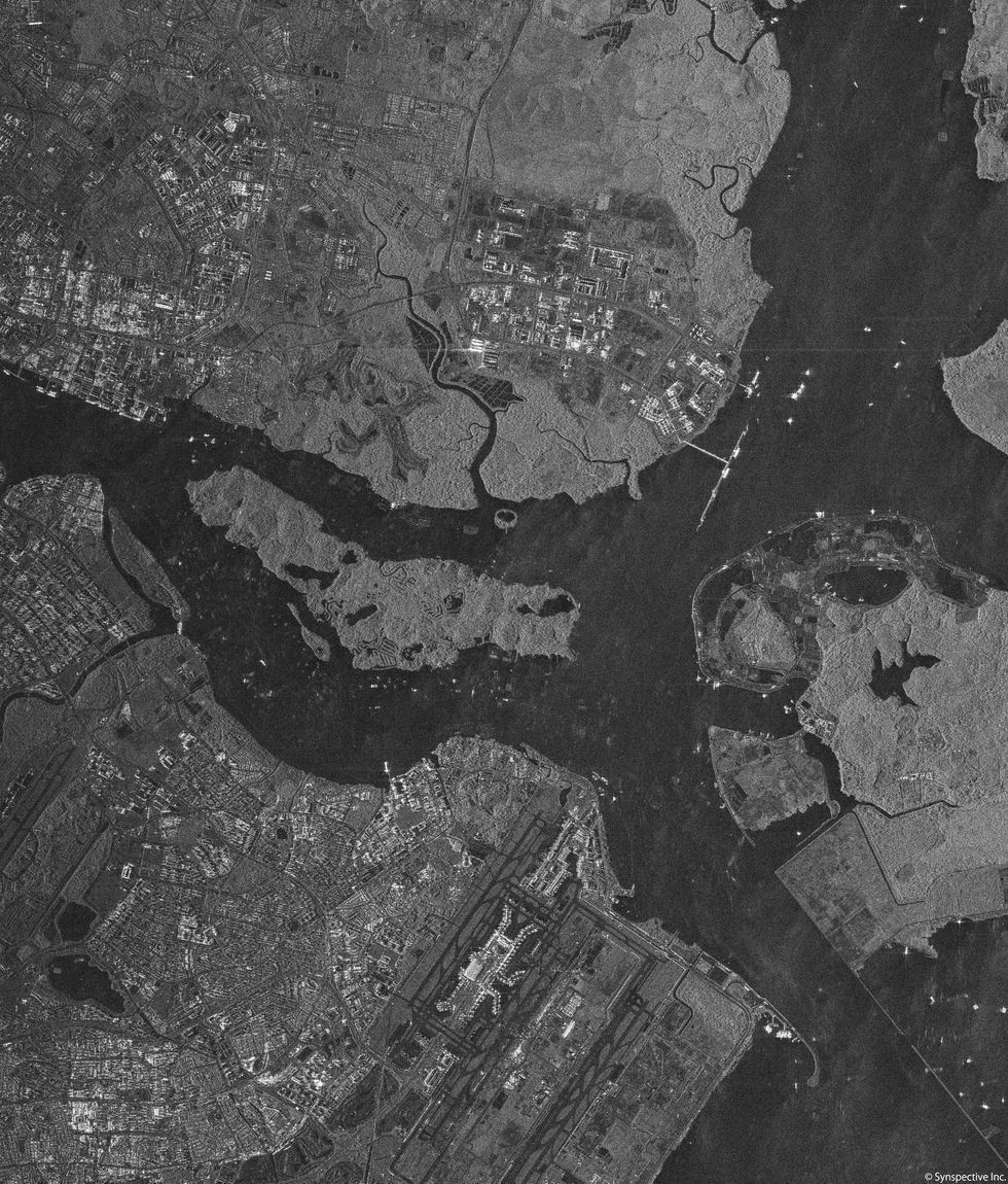 This Synspective SAR “Stripmap” image, taken in December 2021, features Singapore’s Changi Airport. Mainly built on reclaimed land, Changi requires regular monitoring for possible subsidence, a potentially dangerous ground settling that SAR satellites can monitor from orbit.Synspective
“Small SAR systems should be understood as complementary to optical systems,” says Carlos Lopez-Martinez, associate professor at the Technical University of Catalonia in Barcelona. “Nevertheless, SAR is the more reliable technology to acquire time series of images of the Earth’s surface, as data acquisition is almost independent of weather conditions.”
On the other hand, he notes there are also downsides. “Small satellites have very small capacity to take images due to reduced memory and the limited power available. This drawback may in part be solved by having large constellations,” says Lopez-Martinez.
Synspective’s two orbiting satellites weigh around 100 kilograms, while the next series of satellites will be larger and weigh 150 kg. “These second-generation satellites will have a bigger battery capacity so we can take more images and download them to ground stations faster,” says Obata. “Additional thrusters will also help us better maintain a constant altitude.”
The SAR satellites use two modes to collect surface image data. With the radar fixed, Stripmap mode illuminates a swath of ground up to 30 km in length using a continuous sequence of pulses, while in Sliding Spotlight mode, the radar beam is steered to illuminate a series of selected points over a 10-km range. Operating in the microwave X band and employing single-beam polarization (designated as “VV,” which means vertically transmitted and vertically received), the modes provide ground resolutions of 3 meters and 1 meter, respectively.
Via its two SAR satellites, Synspective can already offer some remote monitoring options, says Abhinandan Arya, vice president of Synspective’s applied science and solutions. To do this, Synspective adds its own data to SAR data made freely available from the European Space Agency’s Sentinel-1 program, Japan’s space agency’s (JAXA) ALOS-2 mission, and by obtaining data from other commercial satellite missions. At present, Arya says, the company can provide land-displacement monitoring and flood-damage assessment, and it is developing applications for disaster-damage assessment, forestry-inventory management, and offshore-wind assessment.
Arya says the company uses its own software as well as third-party applications and open-source software such as the U.S. Geological Survey’s InSAR mapping technology. For example, Synspective has taken SAR images of Singapore’s Changi Airport. Since the airport is built mainly on reclaimed land, it requires frequent monitoring to identify any subsidence. Monitoring such land displacements, Arya says, reduces costs and time compared to conventional labor-intensive methods.However, with thousands of satellites from numerous space startups expected to be in orbit during the next several years, Synspective can expect stiff competition, at least overseas.
“Private companies launching small SAR satellites now have lower entry barriers, so the SAR market is growing," Lopez-Martinez says. "Capella Space, ICEYE,Spacety, and Umbra are just some of the companies Synspective can expect to have to compete with in the global market.”
- Spacety Has Big Plans for Small Satellites - IEEE Spectrum ›
- Satellite Imagery for Everyone - IEEE Spectrum ›
- For NASA, Iceland’s Lava Fields Mimic Venus’s Hellscape - IEEE Spectrum ›
- Satellite Radar Sharpens Ukraine Dam Collapse Questions - IEEE Spectrum ›
- AI Generates 3D City Maps From Single Radar Images - IEEE Spectrum ›