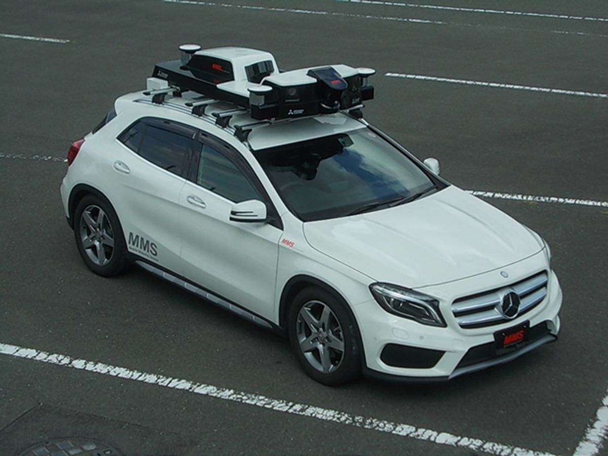
A consortium of 15 Japanese automakers and manufacturers that make components and systems for cars—including Toyota, Honda and Nissan, as well as Mitsubishi Electric, map makers, and others—have come together to create detailed, high-definition 3D maps to help usher in safe autonomous driving. Japan’s government is backing the project as part of its effort to have driverless vehicles on the road in time for the Tokyo Olympics in 2020. The 2020 target date has had the effect of focusing the country’s robocar efforts to prevent Japan from falling behind similar efforts underway in the United States and Europe.
Mitsubishi Electric is leading the project—dubbed Dynamic Map Planning—and is providing a new, compact version of its vehicle-mounted mobile mapping system. Mitsubishi began marketing a version of the system, the MMS-G220, overseas in October, and will introduce the commercial version domestically sometime in 2017. The tedious task of mapping Japan’s 30,000 kilometers of expressways—the plan’s first priority—is now underway.
The mobile mapping system (MMS) can be configured to take advantage of various combinations of lidar, cameras, and other sensors, along with a GPS antenna, depending on the application. The devices are assembled to form a single detachable unit designed for easy maintenance. The system, which can be mounted on even a compact car’s roof, draws power from the car’s cigarette lighter socket.
As the vehicle cruises at speeds of around 40 km an hour, the system uses a laser-scanning point cloud technique to gather 3D positioning data of roadside features such as traffic signals, road signage, and lane markings. It can capture objects up to 7 meters away with an absolute accuracy of 10 centimeters, according to Mitsubishi.
A point cloud is a collection of data points formed in space, the position of each point being identified by its X, Y, and Z coordinates. When light emitted by a laser scanner is reflected back from an object or surface, that information is recorded as a data point. Point cloud data alone would not be sufficient to identify objects clearly, so in post-processing, it is superimposed on synchronized camera images taken at the same time. This information-rich combination is then processed to create 3D maps. Color can also be added at this time.
With standard laser equipment, the Mitsubishi system collects 27,100 data points a second. With optional high-performance laser scanners, that number is raised to one million points a second. The mapping system can be equipped with long-range, high-density laser scanners that provide detailed images of cityscapes or roadside buildings.
To keep track of where these objects are in space, the system relies on GPS, an inertial measurement unit, and a wheel-mounted odometer to help calculate the position of the vehicle. For even greater accuracy, the mobile mapping system will also make use of the nascent Quasi-Zenith Satellite System, a Japan-centered commercial satellite system that aims to provide centimeter-scale positioning to augment the U.S.-operated GPS service. This is due to go into full operation in 2018.
Shun Kuriaki, manager of Mitsubishi Electric’s IT Solution Department, in its Electronic Systems Group, says that to improve the safety of autonomous driving, more detailed information than is currently supplied by car navigation systems is required. In bad weather, for instance, the effectiveness of various sensors needed to maintain control of the driving task can be diminished to the point where they’re inoperable.
“The MMS 3D maps will provide such additional information as noise barriers, lane divisions and their widths and surface conditions, as well as the location of traffic lights, road signs and other useful information to help improve the safety of autonomous driving,” says Kuriaki,
The system, which is gathering the myriad bits of information needed to subsequently allow vehicles to traverse Japan’s roads without human intervention, is designed to be operated by a person with a notebook PC in the passenger seat. According to Mitsubishi, no specialist knowledge is required to operate the system or to run the post-processing software after the data is collected.
Autonomous driving is just one of several applications for which Mitsubishi is seeking to use its MMS system. “Some special specification versions of our MMS have already been applied to inspection of tunnel linings and road surface conditions,” says Kuriaki. “And we are also studying how to apply the technology to other fields, such as inspection of railway tracks and underground areas.”
With Mitsubishi ready to export its road-scanning technology, it can expect to compete with Google in the United States, and with several companies in Europe.


