Across the ocean, threatened communities in Hawaii, Alaska, and the West Coast got considerably more warning, thanks to the recently completed U.S. Tsunami Warning System. As the waves boomed across the open Pacific, deep ocean sensors sprang to life. About 30 minutes after the quake the first sensor detected a surge in the water column above it and sent out cheeps of alarm. Within another hour, three more sensors had picked up the signal and sent their data to the National Oceanic and Atmospheric Administration's Pacific Tsunami Warning Center. Throughout the long night, most of the 32 deep ocean sensors in the Pacific added their data, allowing the emergency response team to shape their tsunami forecasts long before the waves hit Hawaii, around 9:00 a.m.
Because of the quake's magnitude, the Pacific Tsunami Warning Center was on alert before the sensor data arrived. But experts say the information provided by the ocean network was critical to forecasts. In its first major test, the new warning system passed with flying colors.
"I think we can give a grade of an A plus," says Eddie Bernard, director of NOAA’s Pacific Marine Environmental Laboratory, where the deep ocean sensors were built. The last of these sensors, called Deep-ocean Assessment and Reporting of Tsunami (DART) stations, were installed in March 2008. The four DART sensors closest to the quake's epicenter performed exactly as required, Bernard says. "They were all working, they all picked up this tsunami, and they were all used to produce forecasts for Hawaii and the West Coast that were about 85 percent accurate when you compare the forecasts with the actual tsunamis observed at the tide gages."
The animation below shows the tsunami rolling away from the quake's epicenter; the four small yellow squares are the four closest DART stations.
The sensors are anchored to the ocean floor, and they measure the pressure of the water column above them. As a tsunami passes above a sensor, the extra water increases the pressure and triggers an alert. The seafloor sensor then sends its data to an anchored buoy that's floating nearby on the ocean's surface, which in turn sends the info to government satellites. From there the data is beamed to tsunami warning centers, where experts combine those measurements of the approaching waves with precise maps of the ocean floor. That allows the response team to predict how a wave will behave when it nears the shore and reaches coastlines and harbors, and to issue tailored forecasts.

Christian Meinig, who works with Bernard at the Pacific Marine Environmental Laboratory, says today's events illustrates the need for deep ocean sensors. Although the tsunami probably caused billions of dollars of damage and contributed to Japan's growing death toll, it still caused far less devastation than the 2004 Indian Ocean tsunami, which killed 230,000 people. "That shows you how complex this really is," says Meinig. "Information about the earthquake's Richter scale magnitude doesn't tell you enough. You need to understand what happened in the water."
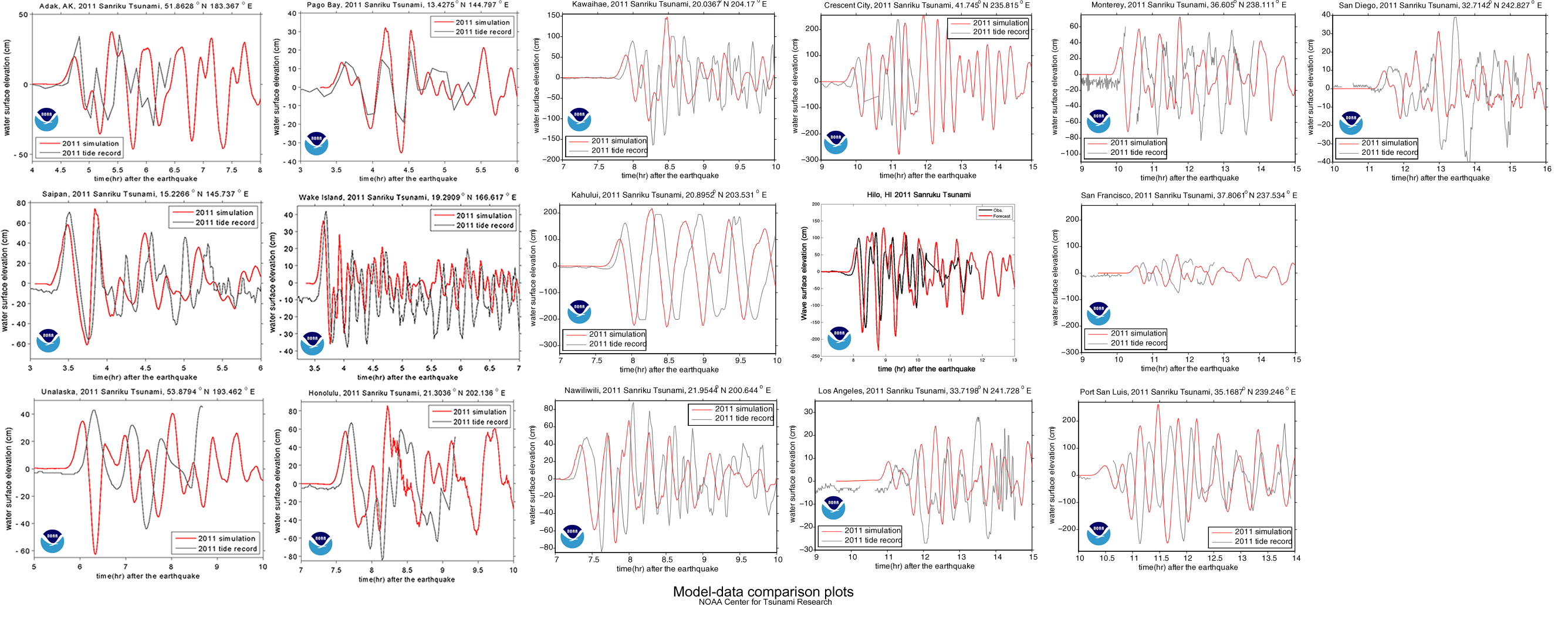
Meinig notes that open ocean sensors receive a very clear signal. "What you have in the deep ocean is a wave that hasn't reflected off any shoreline, so it's a very clear pulse. Later as it reflects off islands you get these interference patterns, just like when you throw a rock in the water." That clarity shows in the comparison charts NOAA has already made to match its predictions against the actual water level recorded by tidal gages.
In the end, Hawaii and the West Coast didn't receive devastating blows. In a press conference this afternoon, NOAA Deputy Assistant Administrator Laura Furgione said Hawaii's largest waves were under 5 feet. Crescent City, California seems to have been hit the worst; its harbor was damaged by an 8-foot wave. But thanks to the early warning system, alarms did sound on the threatened coastlines, residents were evacuated, and roads were closed.
In Japan, where residents had only minutes to respond to warnings, the situation was obviously worse. "Near-shore tsunamis are a completely different problem," says Meinig; "there's very little technologically that we can do."