The Conversation (0)
On 1 April, a brigade of U.S. Army tanks moved in for a nighttime assault east of Karbala, near Iraq’s Euphrates River. The lead company’s commander, Captain Stuart James, planned to pass between two other U.S. units, beyond which lay enemy territory. Once clear of the other units, James would give the order ”Red free,” which meant, essentially, ”Fire at will.” What he didn’t know, though, was that a U.S. scout platoon was on the opposite bank, on a path that would take it directly in front of James’s tanks. Shrouded by a moonless sky, the scouts moved unseen. It was a disaster in the making.
But on a computer screen mounted in his Abrams tank, James had been watching a map of the vicinity. He spotted a blue icon moving in from the right: the scout platoon. Instead of ”Red free,” he keyed his microphone and barked a single word: ”Hold!”
Both James’s and the scout platoon’s vehicles had recently been equipped with a new satellite-based tracking unit that got its first real test in Iraq. Every five minutes or so, an antenna mounted on each vehicle was automatically sending out its Global Positioning System (GPS) coordinates; that signal bounced to a satellite and back down to a ground station in Kuwait [see diagram]. There, a server received updates from all the vehicles--as well as enemy locations from other sources--and sent back an aggregate set of positions to each tracking unit. James’s computer screen refreshed to show the new locations--blue icons for friendly forces and red for the enemy--against a digital map or satellite image.
”I was able to look on my screen and see where my friendly units were to my left, to my right, to my front, to my rear, and I was able to pass that information immediately down to my platoon,” James later said. ”Fratricide was basically eliminated.”
The big picture
In an age of sophisticated battlefield video games, where a single player can control dozens of tanks, aircraft, and other vehicles at a time, one might be forgiven for assuming that real-life soldiers have the same capability. They don’t. At times, they don’t even know their own locations, shuffling through dozens of paper maps and peering at GPS devices. Even commanders have at best a general idea of where their various units are at any given time. In war rooms, troop positions are designated by pins stuck into maps, the accuracy dependent on how often units radio in their positions and how well they read their maps.
That all changed in Iraq. For the first time ever, any soldier, from a private driving a truck to the commanding general at the U.S. Army’s headquarters in Kuwait, could watch on-screen as tanks, helicopters, and other vehicles moved across the battlefield. With this new blue-force tracking technology--known, somewhat cumbersomely, as Force XXI Battle Command Brigade and Below, or FBCB2--they now had what military strategists have long considered the battlefield’s Holy Grail: a common operational picture. That picture let everyone know what was happening as it happened.
For soldiers in the field, FBCB2 allowed them to navigate even in blinding sandstorms, to coordinate attacks with unprecedented precision, and to exchange text messages on the fly. That last feature proved essential during the Army’s now-famous race across the desert to Baghdad. Many units were moving so fast, they fell out of radio range; nor could they rely on the Army’s usual satellite-based communications networks, which take several days to set up and tune.
Unfortunately, only about one in 10 Army vehicles deployed in Iraq had the benefit of an FBCB2 onboard. The 4th Infantry Division, based at Fort Hood, Texas, was the only one to have an FBCB2 installed on every vehicle. In fact, because of the 4th’s role in beta testing the FBCB2, the press dubbed it ”the most technologically advanced fighting force in the world.” Other divisions were given 100 to 200 FBCB2s, to place on key vehicles.
The FBCB2 would have averted the much-reported incident in which Private Jessica Lynch was captured. Without adequate navigation, her maintenance vehicle took a wrong turn and collided with another Humvee, killing some of the convoy’s crew.
The FBCB2 also prevents friendly fire. While U.S. combat deaths have fallen dramatically with the rise of long-range, precision-guided weapons, that greater precision hasn’t eliminated fratricide, the military’s term for the accidental killing or injuring of one’s comrades. What’s more, the proportion of fratricide deaths has remained static and may even be on the rise.
During World War II, friendly fire accounted for anywhere from 2 to 21 percent of U.S. casualties, depending on whose figures you use. During the first Gulf War, by contrast, 24 percent of U.S. casualties came from fratricide. While casualties from the Iraqi War are still being tallied, it’s already known that friendly fire accounted for some 35 U.S. and allied deaths during the first six weeks of conflict, out of a total of 189 fatalities [see photo].
The Army uses a hodgepodge of techniques to avert such tragedies, from painting the roofs of vehicles with bright colors, to strapping luminescent tape on uniforms, to bolting thermal panels on tanks that are visible in the infrared. Some units in Iraq also carried radio combat-ID tags to distinguish friend from foe, but the ID systems used by the various armed services weren’t always interoperable. In contrast, among those units with even a partial FBCB2 deployment, the incidence of fratricide fell to zero.
The guts of the machine
The FBCB2 computer consists of a ruggedized notebook with a touchscreen and keyboard that is mounted in a vehicle--typically an Abrams tank, Bradley fighting vehicle, or Humvee [see photos]. On the color liquid-crystal display [see photo], the soldier sees either a digital map or satellite imagery overlaid with icons representing the vehicle’s location, other FBCB2 vehicles nearby, any known enemy units, and objects such as minefields and bridges. The user can scale the maps as needed, much like zooming in and out on MapQuest to show more or less detail. On-screen buttons pop up windows for composing and reading messages.
As originally conceived, the FBCB2s communicate over a terrestrial digital radio network, sometimes referred to as a Tactical Internet. Two types of radios--the Enhanced Position Location Reporting System and the Single Channel Ground and Airborne Radio System--form the backbone of this Tactical Internet.
On the plains of central Texas, where the 4th Infantry Division trained with the FBCB2s, such a system works well. But there are many instances where these, or any terrestrial radios, can’t connect: in built-up urban areas, in the mountains, and when vehicles simply move out of range. The solution, to move data by satellite, arose in the aftermath of an unhappy incident in Kosovo.
Tracking in the Balkans
On 31 March 1999, three U.S. soldiers were driving near the Macedonia-Kosovo border on a routine patrol when Serbian troops captured them. After Serbian television broadcast video of the prisoners, visibly bruised and bleeding, the incident blew up into an international dispute, with the Serbs claiming the soldiers had crossed into Yugoslav territory and the United States claiming otherwise.
While the soldiers’ release was eventually negotiated by the Reverend Jesse Jackson, the commander of the U.S. Army in Europe at the time, General Montgomery C. Meigs, now retired [see photo], vowed such an incident would never recur on his watch. He’d already been looking into ways to improve how the Army tracks and communicates with vehicles in the field. After the border incident, Meigs put the project, which became known as the Balkan Digitization Initiative, on the fast track.
The region’s mountainous terrain rendered the Army’s regular radios useless in many areas, so a satellite-based tracking system became the obvious choice. Officials considered a number of off-the-shelf systems before selecting Qualcomm Inc.’s OmniTRACS network, an equipment management system that simultaneously tracks hundreds of thousands of commercial trucks throughout North America. OmniTRACS is also used to track shipments of nuclear material and transfers of prisoners.
Each OmniTRACS vehicle is equipped with a satellite antenna and internal GPS, plus a display for sending and receiving text messages. At defined intervals, typically every five minutes, the antenna automatically sends a position report to a Ku-band satellite (10.7-18.0 GHz), which bounces the signal to Qualcomm’s hub in San Diego, Calif.; from there, the signal gets routed over the Internet to the truck fleet’s management facility. Messages being exchanged between the trucks and their headquarters also follow this path; the Qualcomm network fields some seven million such messages a day.
For the Balkans, the Army opted to use Qualcomm’s communications and network management infrastructure, but to replace its display with an FBCB2 computer. Working with the Army’s Program Executive Office for Command, Control and Communications Systems at Fort Monmouth, New Jersey, a team of engineers from TRW Inc., MITRE Corp. (my employer), Qualcomm, and Tobyhanna Army Depot (near Stroudsburg, Pa.) designed the system architecture, software, installation kits, and a satellite hub facility.
For communications, the Department of Defense (DOD) leased a transponder on the Intelsat 902, a commercial Ku-band satellite, and built a hub in Mannheim, Germany. MITRE and TRW engineers wrote software to let the FBCB2 communicate through its Qualcomm antenna, let vehicle occupants send messages to one another, and let FBCB2 position data be displayed in the Global Command and Control System (GCCS), the classified computer network used by top-level U.S. brass.
Making the system secure was another matter. Qualcomm’s network is unencrypted--all data are sent in the clear. The underlying code-division multiple-access (CDMA) protocol uses a low-power, spread-spectrum signal that is difficult, but not impossible, to detect and intercept. For obvious reasons, though, the U.S. military sets the security bar somewhat higher. To that end, encryption cards were installed in every FBCB2 computer. Additionally, a so-called guard computer was added to act as the interface between the unclassified network and the DOD’s classified Siprnet, for Secret Internet Protocol Router Network. These guard computers are basically desktop PCs that the U.S. Naval Research Laboratory (Washington, D.C.) customizes and certifies for joining unclassified and classified networks within the DOD.
Compared to most military technology, which can take years if not decades to develop, the Balkan Digitization Initiative was completed in record time. By May 2000, a year after the captured soldiers’ release, the network was operational. In total, 140 vehicles in Bosnia and 470 in Kosovo had the system installed. In addition, over a thousand logistics vehicles were equipped with regular OmniTRACS units.
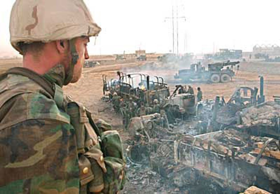
Photo: Eric Feferberg/AFP
A U.S. Marine from the 2nd Battalion, 8th Marine Division, looks at vehicles destroyed by accidental artillery or mortar rounds from another Marine unit near An Nasiriyah, Iraq. No Marines were killed, but 31 were injured. The Army’s new blue-force tracking system averted such “friendly fire” incidents in those units that had it.
Soldiers immediately deemed it a success. In areas where their radios didn’t work, they still could, and did, communicate by text messages. For the first time, they could display their exact position on a continually updating map--mistakes like crossing into enemy territory no longer posed a danger.
From the Balkans to Afghanistan
It was a great start, but left much room for improvement. Most notably, satellite-based communications have limited bandwidth, which in turn limits the size and number of messages that can be sent. So, although the FBCB2 system is technically capable of sending graphics and other large files, soldiers are discouraged from doing so.
Also, the area covered by the Intelsat 902 satellite was less than ideal. This became obvious when Meigs, the U.S. Army’s European chief, decided to deploy FBCB2s to an airborne brigade based in northern Italy. The brigade’s area of operation comprises all of Europe and a good portion of Africa, too, much of it outside the 902’s footprint. In fact, no single Ku-band satellite covered that entire area. But using multiple satellites would mean building multiple hubs, a solution deemed too complicated and costly.
Meanwhile, the Army was ramping up for its assault on Afghanistan and looking for a way to track ground forces. Here again, the area of operation would be too vast for a single Ku-band satellite. L-band satellites (1.5-1.6 GHz), in contrast, are designed for mobile communications, and they typically have much larger footprints and greater bandwidth. The L-band waveform also performs better in bad weather and on helicopters and other aircraft.
As it happened, the Army had just begun fielding an L-band satellite-based tracking network, for monitoring the whereabouts of logistics vehicles, like fuel, water, and supply trucks. This so-called Movement Tracking System (MTS), much like Qualcomm’s OmniTRACS, could display each truck’s location. But unlike the FBCB2, it wasn’t intended for higher-level command and control.
Just as in the Balkans, Army engineers took the existing MTS communications and network infrastructure, but replaced the MTS computer in the vehicle with an FBCB2. MITRE also developed a microrouter that allowed the FBCB2 units to seamlessly switch between Ku- and L-band satellites, as well as other satellite and terrestrial communications. In tests at Fort Hood in February 2002, the L-band-based FBCB2 worked successfully.
The Army was also eager to track its helicopters. That proved particularly tricky because a helicopter’s cramped cockpit has little room to accommodate an FBCB2 display. Also, the antenna had to be mounted on the craft’s exterior and yet be both protected and aerodynamic. Through some painstaking negotiations and design iterations, the engineers worked through these and other issues with the military units that would actually use the systems. The definitive test came in June 2002 at Fort Campbell, Kentucky, when several helicopters from the 101st Airborne Division exchanged messages with FBCB2 vehicles on the ground. For the first time ever, air and ground assets were integrated into a common operational picture.
On to Iraq
The war in Iraq would test the limits of blue-force tracking. During the fall and winter of 2002-2003, the Army set up a satellite hub facility at command headquarters in Camp Doha, Kuwait. It also leased six spot beams on Thuraya-1, a geosynchronous L-band satellite owned and operated by a consortium of telecom companies; as a backup, the Inmarsat 3F5 was also leased.
About 1100 FBCB2 computers were installed in units already in Kuwait and Afghanistan and other units not yet deployed. By February, elements of the
V Corps’ 3rd Infantry Division, the 101st Airborne Division, the 82nd Airborne Division, the 1st Armored Division, and the 1st Marine Expeditionary Force had the new blue-force tracking capability. As stated earlier, though, not every vehicle in these divisions had an FBCB2. Counting the already equipped European units and the 4th Infantry Division, a total of 6000 FBCB2-equipped ground and airborne vehicles were poised to invade Iraq.
As fighting began on 20 March, the advantages of blue-force tracking immediately hit home. Commanders at Camp Doha, as well as senior leaders back at the Pentagon, watched the forces maneuver in near real-time and could choreograph troop movements as never before. The system also made it easier to quickly locate downed helicopters and other disabled vehicles. And, as in the Balkans, there were many instances where FBCB2 messaging became the only communications available.
The experience of Lieutenant Colonel John W. Charlton, a tank commander with the 3rd Infantry Division, was fairly typical. Although he holds a master’s degree in computer information systems, he was reluctant to give up his ”old school” methods, preferring paper maps to the FBCB2 display.
The turning point came on 23 March, when his unit was called unexpectedly to As Samawah, about 240 km southeast of Baghdad and still held by Fedayeen Saddam militia. Charlton had no detailed maps of the town, and a vicious sandstorm had cut visibility to near zero.
”We ran into problems...when we tried to navigate around the As Samawah train station,” Charlton recalled later. ”Vehicles were getting stuck on converging tracks and had to maneuver around several buildings that weren’t identified on the maps.” But by flipping between maps and satellite imagery on the FBCB2, he said, ”we were literally maneuvering by instruments like pilots do in bad weather. The imagery and GPS functions of the FBCB2 system allowed us to bypass the train station....I never used another paper map product for the rest of the war and fought every fight thereafter using FBCB2.”
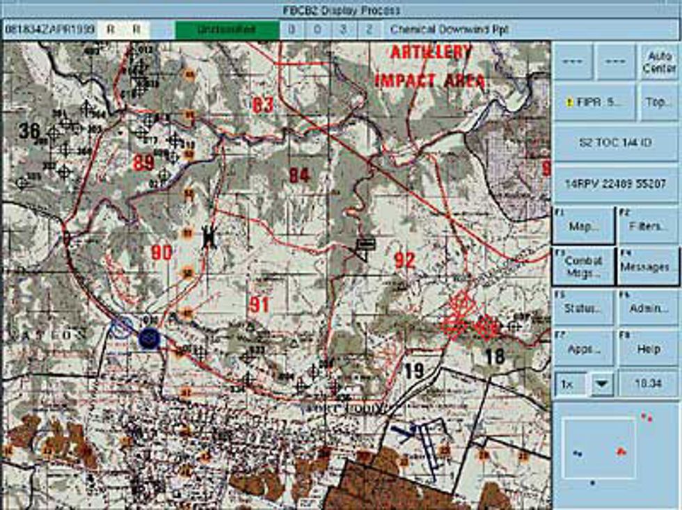
Photo: Northrop Grumman Corp.
The FBCB2 screen shows friendly forces as blue icons and enemy forces as red. Minefields are circled in green, and bridge icons indicate whether they are passable. The right-hand buttons are used for sending messages, changing the map display, and accessing other functions. The map shown is of Fort Hood, Texas, where the 4th Infantry Division, which tested and first fielded the FBCB2, is based.
What’s left to do
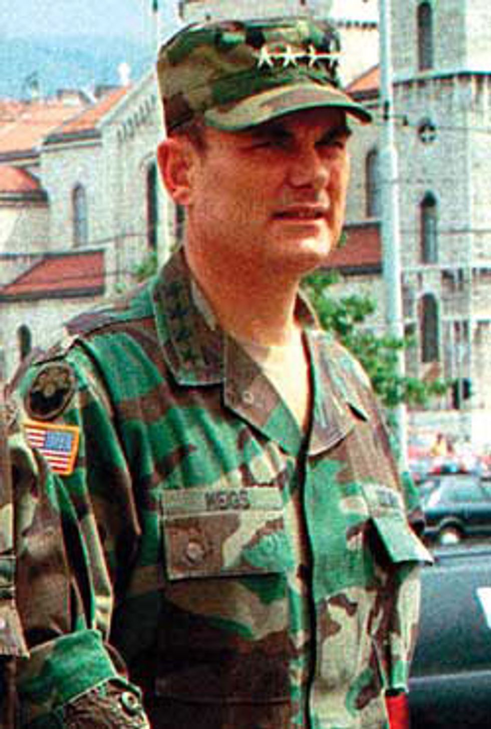
Photo: Hidjet Delic/AP
As head of U.S. Army forces in Europe during the 1990s, General Montgomery C. Meigs spearheaded the effort to develop the blue-force tracking network that, with modifications, was later deployed in Iraq.
With the main battles in Iraq now over, senior Army leaders are eager to digitize the remainder of the force. Over the next several years, FBCB2s will be fielded to those units that don’t currently have them, and additional systems will be provided to those that already have some FBCB2s in place. In addition, a satellite infrastructure is needed in the Asia-Pacific region.
Army engineers and contractors are developing portable versions of the FBCB2 to give to individual soldiers. Last spring, 200 U.S. soldiers in Iraq tested non-FBCB2 handhelds and tablet PCs that had been ruggedized and equipped with GPS cards and wireless modems. Special operations forces, who typically travel on foot, already carry a handheld computer known as the Grenadier BRAT. The Defense Department has a demonstration program under way this year to ensure that all such tracking devices will be interoperable.
Greater satellite bandwidth will also be needed to implement the full suite of FBCB2 functions, such as transferring maps and other large files and allowing more collaboration over the network. Moreover, having a satellite network that is certified to operate at a classified level would eliminate the guard computers. Enabling the FBCB2s to switch seamlessly between the satellite and digital radio networks also needs to be addressed.
Despite the FBCB2’s remaining shortcomings, its blue-force tracking powers have already proven themselves in battle. In testimony before the U.S. Senate, Secretary of Defense Donald Rumsfeld cited it as one of the ”transformational” technologies that proved critical during the Iraqi conflict. As Stuart James, the tank commander at Karbala, put it, ”The fog of war is why units lose. [The FBCB2 offers] simultaneous, real-time synchronization. It reduces the friction of war by a hundredfold.”


