San Diego’s Smart Streetlights Yield a Firehose of Data
San Diego’s installation of 3,200 smart streetlights is slightly behind schedule, but the city has already ordered more
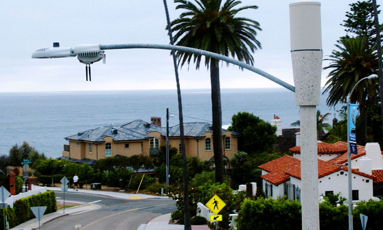
San Diego’s network of smart streetlights, which has been rolling out since early 2018, continues to grow. To date, some 2,000 of the sensor-laden devices have begun gathering pictures, sounds, and other data.
So far, the city has focused on the image data, using it to count pedestrians and cars as they move around the city. This data is only just starting to feed into the way the city designs and manages traffic flows, and any consumer applications remain far in the future, says Erik Caldwell, the city of San Diego’s interim deputy chief operating officer for smart and sustainable communities. Officials are still talking through all other possible applications, such as using the streetlights to locate gunshots, track airport noise, or monitor air quality.
But the city is already fond enough of the sensor-laden lamps that it has placed an order with manufacturer Current by GE for an additional 1,000. Meanwhile, the initial 3,200 streetlights will finish being installed in the next month or two.
The rollout has fallen a bit behind schedule, admits Caldwell. As of last October, the city expected most of the network to be complete in May 2018. But Caldwell says that the original deadline was aspirational, and he isn’t too dismayed by the current pace of installation.
And the streetlights installed to date have given the city plenty of data to work with.
Says Caldwell of a recent test examining whether the streetlights could identify open parking spaces, “We just completed a pilot demonstration project benchmarking the system against parking meters with built-in sensors, against parking transaction data, and against an intern with a clipboard. We found that the streetlights provide the best information.”
With the accuracy of parking data verified, Caldwell says, the city is now preparing to take action on that information. “We thought we were using spaces 60 percent of the time,” he said, “but data we from the streetlights says we are using them 90 percent, which is overutilized. So we are thinking about pricing, whether we should have more parking in certain areas, whether we should expand the metered network.”
The city is also getting ready to use the parking data to help people find a parking space. “We’ve had a couple of pilot applications built,” he says, “but haven’t launched a consumer-facing version yet.”
More useful to city planners than parking will be what Caldwell calls “mobility” data—information on how people and vehicles move through the city.
Right now, he says, the city uses traffic flow models to determine where to place stop signs, stop lights, and one-way streets, as well as how to time traffic signals. Those models currently base their analysis on the number of people living and working in particular areas as well as the number of vehicles registered to addresses in those areas.
“What is revolutionary is to have near real-time information about how people are moving,” Caldwell says. “That gives us the ability to see things we haven’t seen before. We can look at a baseball game at Petco Park downtown, and see how that affects people’s ability to move through the environment. We can see how a law enforcement event, like a traffic stop, impedes the ability to move.”
Seeing all this information, he says, city managers have been inspired to try to help police and fire vehicles get to emergencies faster:
“We want to see if we can build a tool, based on a more accurate model of how traffic and pedestrians behave, to optimize traffic for law enforcement. Say, when a fire call comes into a fire station, right now, the doors of the fire station go up, and the location information goes into a GPS system. But today, when the firefighters pop onto the road, they are back in the ‘80s, strobing the light and hoping cars will get out of the way. It would be easier if we could use the traffic signals and street lights to clear the road from Point A to Point B, and then have the [streetlight] system detect how the fire truck is moving through the street, restoring traffic flow behind it. That would save us money on fire stations, because we build them based on response times. Improving response times means we might not need as many stations.”
“We didn’t anticipate this use case,” said Caldwell, “but it looks like we can do it.” And he expects to find more such uses for the streetlights as various departments that manage the City of San Diego’s operations have time to study the data that comes in.
“It’s not super-exciting yet in terms of applications from the outside looking in,” Caldwell says. “But it’s like we asked for a cold drink of water and got shot in the face with a firehose; it’s a matter of figuring out how we are going to take in this data, first using it internally, and then putting in policies and procedures to make it available for use by the public, including application developers.”
Caldwell also has a few words of advice for other cities eager to start their own smart streetlight projects. “When I talk to other cities, I tell them they should think about the things that we are thinking about now, that is, how to teach department directors some data science, how you process the data and get it into a format that is usable for the community,” he says. “Those aren’t things you think about when you have a small pilot project, but when you have 2,000 nodes up, it becomes apparent that you should.”
And indeed, other cities are following in the path that San Diego has been lighting, though, in the United States at least, San Diego will likely remain the largest installation for some time. Atlanta, Ga., and Portland, Ore., have also begun rolling out sensor-laden lamps from Current, but both projects are still in the pilot stage.
Correction made 17 January 2019.
Tekla S. Perry is a senior editor at IEEE Spectrum. Based in Palo Alto, Calif., she's been covering the people, companies, and technology that make Silicon Valley a special place for more than 40 years. An IEEE member, she holds a bachelor's degree in journalism from Michigan State University.