Researchers have produced for the first time a three dimensional map of the underside of Antarctic sea ice, giving them a tool to measure the thickness of the ice in unprecedented detail. Accurate measurements of ice thickness are crucial for tracking the effects of climate change.
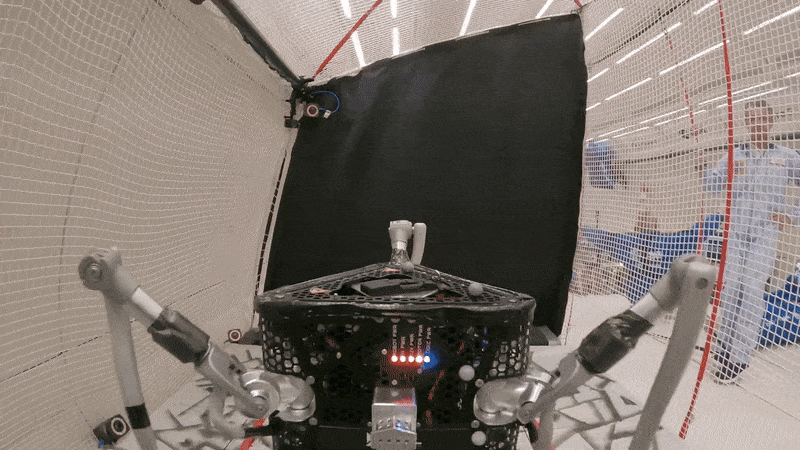
The team of scientists from eight countries sent an autonomous underwater vehicle (AUV)—basically, a submersible robot—under the ice. The AUV traveled in a lawnmower-like grid pattern 20 meters below the ocean's surface and mapped the inverted peaks and valleys of the ice using multi-beam sonar. AUVs have been used in the past to map the sea floor.
The scientists also measured the thickness of the snow and ice above the water using helicopters equipped with a scanning LiDAR (which uses light to image objects), high-resolution aerial photography, GPS, and a microwave radiometer.
The combined data from above and below the ocean's surface allows researchers to produce an accurate measurement of the thickness of the ice—the holy grail of climate change tracking tools. The results also set a baseline to which researchers can compare changes in ice thickness over time, allowing them to better understand the effects of climate change.
In the past, researchers have measured the thickness of Antarctic ice by taking drill line measurements or by observing the thickness of the ice while moving through it on a ship. Surface area is more easily measured, and has been for years using satellite images, but only offers limited clues to how much ice volume exists.
The inverted 3D map comes from a collaboration of 50 scientists from eight countries who are on a two-month voyage on Australia's research vessel Aurora Australis. The map is one project in a larger mission to investigate the relationship between sea ice environment and ocean ecosystems. The AUV, which launched from the Aurora, is operated in partnership with Woods Hole Oceanographic Institution based in Woods Hole, Massachusetts.
Photo: AUV team/Australian Antarctic Division
Emily Waltz is a features editor at Spectrum covering power and energy. Prior to joining the staff in January 2024, Emily spent 18 years as a freelance journalist covering biotechnology, primarily for the Nature research journals and Spectrum. Her work has also appeared in Scientific American, Discover, Outside, and the New York Times. Emily has a master's degree from Columbia University Graduate School of Journalism and an undergraduate degree from Vanderbilt University. With every word she writes, Emily strives to say something true and useful. She posts on Twitter/X @EmWaltz and her portfolio can be found on her website.