Satellite images of North Korean missile testing sites or nuclear reactor facilities can sometimes reveal smears of yellow or befuddling brown objects at certain times of the year. A casual armchair observer might suspect those patterns as indicating something nefarious. But they actually represent a mundane harvest practice—North Korean workers often dry out their corn harvest on pavement before putting the harvested crop into brown sacks.
Growing swarms of commercial satellites have provided new tools for both government spies and independent analysts to peek inside North Korea as the isolated “Hermit Kingdom” races to strengthen its arsenal of nuclear weapons. But the process of understanding satellite images of suspected North Korean missile or nuclear test sites is far from easy and requires more than just the latest satellite imaging technology. The best analysts need more than the skills to analyze near-infrared imagery or use mapping software—they must also tap into a wide swath of cultural and technical knowledge when trying to figure out what a particular satellite image can reveal about the secretive North Korean nuclear program.
“Satellite imagery interpretation is very interdisciplinary,” says Melissa Hanham, a senior research associate in the East Asia Nonproliferation Program at the Middlebury Institute of International Studies(MIIS) at Monterey, Calif. “You have to be a little bit of an expert in everything, and you have to know your limits.”
Analysts have access to more satellite data than ever these days. Companies such as DigitalGlobe and Airbus have satellites capable of providing high-resolution images of ground objects as small as a third of a meter per pixel for commercial customers. Newer companies such as Planet have deployed constellations of dozens of smaller satellites with lower resolution capabilities around 3 meters per pixel. But the swarm of small satellites can capture more frequent images of locations in North Korea and elsewhere, which provides analysts a new tool for tracking a given site’s normal “pattern of life.”
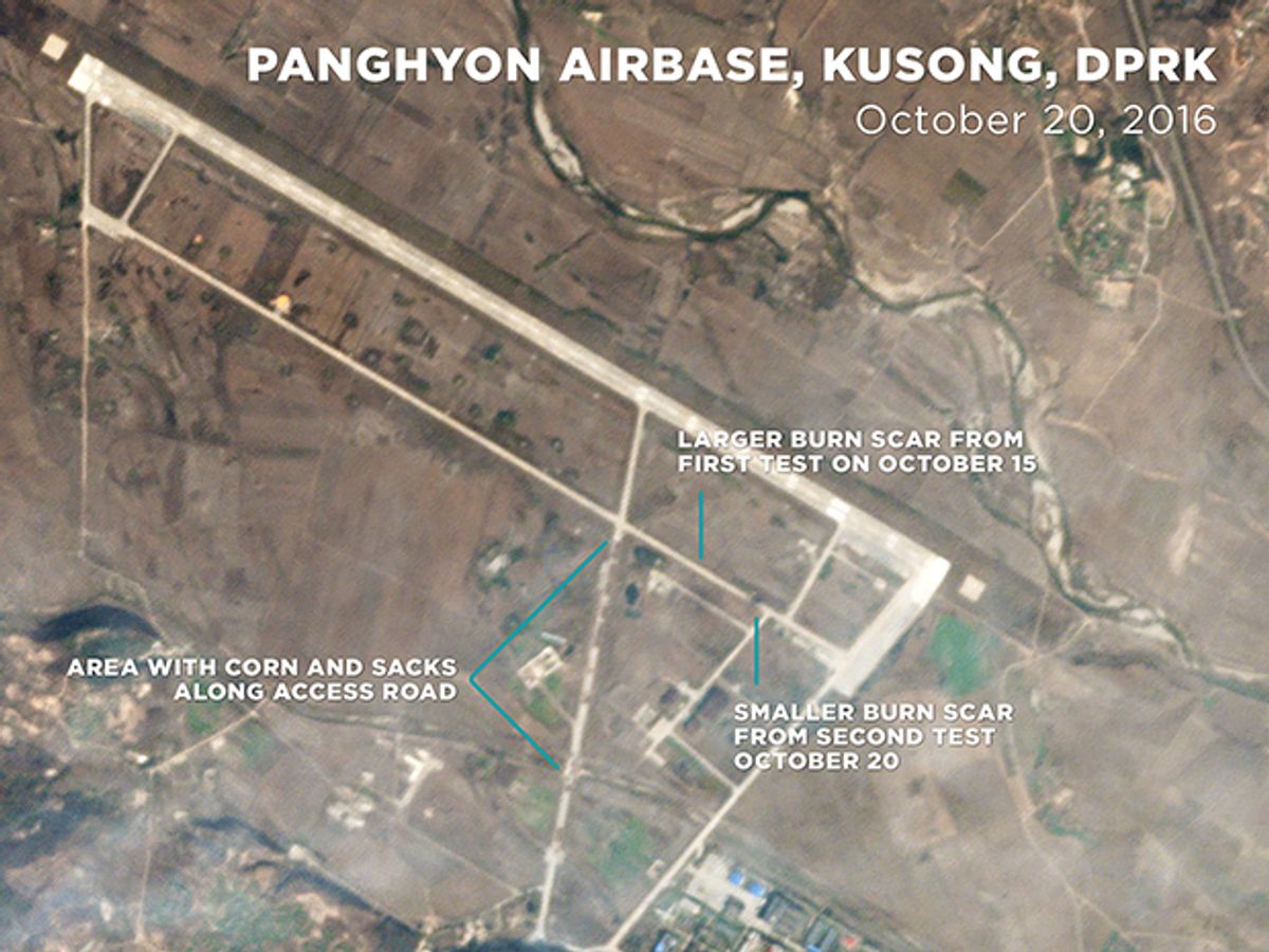
Both increased access to daily satellite imagery and broad expertise on North Korea proved helpful in a 2016 Washington Post analysis by Hanham and her colleagues. Part of their analysis involved identifying corn piled along the access road leading to Panghyon Airbase in Kusong, North Korea, which represents an alternative missile test site for the regime. They were able to quickly rule out the idea that the brown sacks of corn might represent some mysterious equipment related to missile launches.
“While satellite imagery can give you the keys to the castle for a country that is closed off, there is also lots of room for error that context,” says David Schmerler, a research associate at MIIS.
The MIIS researchers used near-infrared satellite imagery to highlight some rather large burn scars left in the surrounding vegetation from two North Korean missile launch attempts that both went awry in October 2016. The sequence of before and after daily images was taken by a constellation of smaller satellites owned by Planet. (More recently, the publication 38 North also made use of Planet’s daily satellite imagery to examine landslides resulting from North Korea’s sixth nuclear test.)
Technical and cultural knowledge go hand-in-hand, says Joseph Bermudez Jr., CEO and co-founder of KPA Associates, LLC and an analyst focused on North Korea's defense and intelligence affairs and third-world ballistic missile development. He recalled being sent an image where someone thought they had spotted filled-in bomb craters left over from the Korean War. In fact, the circles represented traditional North Korean burial mounds where a circular area is cleared of grass for a mound placed in the middle
“There is an incredible range to what people are saying about satellite images of North Korea, and the vast majority of it is inaccurate,” Bermudez Jr. says. “The reason for that is satellite imagery interpretation is a skill that needs to be learned or taught—it needs experience behind it before you reach a level of accuracy that is acceptable.”
Bermudez Jr. usually begins his work by using color correction, sharpening the image and other processing tricks to make a satellite image look as good as possible for inspection. He also rotates the image to the “look angle” that represents the direction from which the original image was captured.
If he has a general idea of where in the image is the activity of most interest—such as a missile launchpad—he will zoom in and compare it with previous images showing the same site. But he also will have his computer software pan slowly across the entire image while zoomed in so that he can get a good look at everything in high detail.
Diverse life experiences and real-world skills among a team of analysts can also prove incredibly helpful. Bermudez Jr. learned about structures as a fireman paramedic earlier in his life. As a wilderness instructor, he also spent a lot of time walking around in the mountains and understanding natural drainage systems such as rivers and valleys. Other analysts may know more about building ships or railroad operations. Each analyst can then build “interpretation keys” based on his or her knowledge to share with others in examining satellite images.
Satellite imagery analysts also benefit from leaning on outside experts in other fields. Hanham has previously tapped into the expertise of a cousin who is a long-haul trucker and her microbiologist mom’s knowledge of lab equipment. “I’ve leveraged my family,” she says.
The community of satellite imagery analysts with deep expertise on North Korea is small. That limited amount of human expertise may prove a bottleneck at a time when commercial satellites continue to build ever-larger databases of imagery on North Korea. But increased use of image-recognition algorithms based on machine learning could help, Hanham says. She and her MIIS colleagues hope to eventually have more of a semi-automated process of identifying certain objects.
Commercial satellites may soon provide even broader space surveillance of North Korea with a wider array of imaging equipment. Some already make use of hyperspectral imaging capabilities that go beyond the visible light spectrum. Others have begun mounting synthetic aperture radar (SAR) that can provide 3D mapping of the Earth’s surface regardless of weather or nighttime conditions.
But regardless of the technologies, interpretation of satellite imagery still depends heavily on the human expertise factor. And experienced analysts are always careful to caution that satellite images represent just once piece of a much larger puzzle when it comes to gathering intelligence on North Korea.
“I’ve run into many cases where people who are imagery analysts believe they have absolute truth,” Bermudez Jr. says. “Satellite imagery is just a single point in time that can only tell you so much.”
Reporting for this story was supported by the Stanley Foundation.
Jeremy Hsu has been working as a science and technology journalist in New York City since 2008. He has written on subjects as diverse as supercomputing and wearable electronics for IEEE Spectrum. When he’s not trying to wrap his head around the latest quantum computing news for Spectrum, he also contributes to a variety of publications such as Scientific American, Discover, Popular Science, and others. He is a graduate of New York University’s Science, Health & Environmental Reporting Program.


