This article is part of our exclusive IEEE Journal Watch series in partnership with IEEE Xplore.
Ever since the Global Positioning System (GPS) first took off in the 1970s, it has been an essential part of many things—whether for personal navigation, agriculture, aviation, or military operations. But relying too much on this single technology involves huge risks if it were to fail or be hacked, which has prompted researchers to explore alternatives.
In a recent advancement, one research team succeeded in using a collection of low Earth orbit (LEO) satellites to calculate their ground location within several meters—outperforming today’s GPS-inertial navigation system (INS) in certain scenarios.
Zak Kassas, the director of the U.S. Department of Transportation’s Center for Automated Vehicles Research with Multimodal Assured Navigation (CARMEN) at Ohio State University, first started exploring alternatives to GPS in 2014 after becoming concerned at the thought of GPS failure. He says that GPS signals can be unreliable in certain situations, such as indoors or under dense tree canopy, and that the jamming of and interference in GPS signals have skyrocketed over the past few years.
“This has disrupted airport and port operations in the U.S. and around the world, caused chaos on rideshares, put vessels into disarray, caused drones to come crashing down, and is becoming commonplace in military conflicts,” he says. “All of this keeps me up at night thinking that we ought to find a backup alternative to [GPS] before it is too late.”
GPS systems currently rely on a constellation of 31 satellites circling in Earth’s medium orbit (about 20,000 kilometers high). But Kassas has his sights set on the tens of thousands of LEO satellites poised for launch over the next decade, which will be about 20 times as close to Earth. That means they’ll have stronger signals, making them more difficult to jam or spoof and more reliable in environments where GPS signals are not. Kassas’s idea is to use a ground receiver to detect the beacon signals of LEO satellites to determine their relative position and then use that information to calculate the position of the ground receiver—in other words, the location of the person or object of interest.
But whereas data from GPS satellites are available to the public, LEO satellites are privately owned, and their beacon signals are not publicly available. Kassas’s team therefore developed an algorithm that can decipher a satellite’s unknown beacon signal.
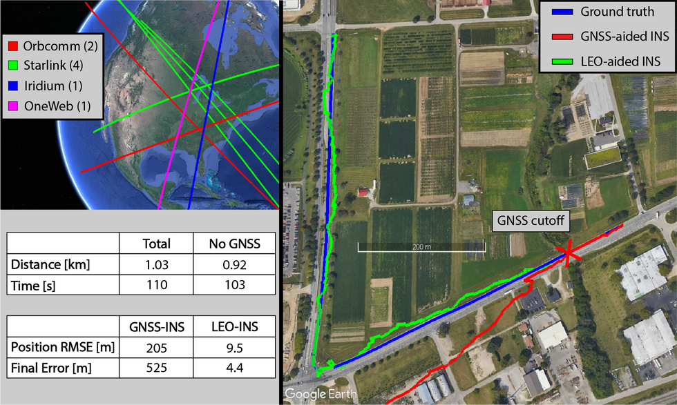 Researchers used their new positioning technique, called STAN [see green line at right], to determine how accurately it could track their position [blue line at right] in a moving vehicle. Sharbel Kozhaya
Next, they developed another algorithm called simultaneous tracking and navigation (STAN). “[STAN] can essentially detect the presence of a LEO satellite, decipher its beacon, and track the signal, while simultaneously estimating the satellite’s position, allowing us to produce an estimate of our distance to the satellite,” explains Kassas.
In 2021, Kassas’s team successfully decoded the signal of Starlink satellites, and used six of these to track their own position on Earth to within 10 meters. Later attempts reduced that tracking distance to just 6.5 meters. In their most recent advancement, they developed a receiver that could work with virtually any satellite constellation and tested it on satellites from four different companies—Iridium NEXT, OneWeb, Orbcomm, and SpaceX’s Starlink—to hone in on Earth locations with even greater precision. The advancement is described in their 2023 IEEE/ION Position, Location and Navigation Symposium (PLANS) paper.
In their paper, the team describes a stationary ground experiment where they were able to pinpoint their true location on the rooftop of their lab in Ohio with an error of about 5 meters, using the four different types of LEO satellites. Kassas notes that this is the first time anyone has been able to crack OneWeb signals for positioning and navigation purposes.
In a second experiment, the researchers mounted their off-the-shelf receiver onto the top of a car and drove while listening to signals from four LEO satellite constellations (one OneWeb, four Starlink, one Iridium NEXT, and two Orbcomm satellites).
When someone is driving or moving and GPS signals are lost, the GPS-INS system estimates the person’s location based on their trajectory, which accumulates errors rather quickly.
In their driving experiment, the research team drove in a car for 100 meters before cutting their GPS off, and continued driving for nearly a kilometer. Whereas the conventional GPS-INS system predicted their location to be about 500 meters away from their true location, the STAN system was just 4.4 meters off—proving that STAN algorithms can be incredibly useful when GPS fails.
DSTANwww.youtube.com
“It is like shooting in the dark, yet hitting your target with an amazing accuracy,” says Kassas, noting that this approach uses numerous unknown variables together to successfully find a target. “We are dealing with satellites whose position is uncertain—we only know where the satellite is to within a few kilometers—and that are transmitting signals that we do not know much about. Yet we are able to use the satellites’ signals to locate ourselves with impressive accuracy.”
Despite these exciting first milestones, Kassas notes, this technology is still in its infancy. For instance, STAN still can’t achieve real-time navigation like GPS, and he says some of their algorithms need refining. “We have still not tested our approach in all environments, so it is difficult to assess whether these signals will allow you to navigate anytime, anywhere, which is the holy grail,” says Kassas.
Nevertheless, the researchers have filed for patents and say they have received widespread attention from startups and tech giants from across diverse industries who are interested in discussing commercialization. If all goes according to plan, STAN algorithms may lead us down a path where an alternative or backup to GPS exists.
- The Networks That Aim to Track GPS Interference Around the World ›
- FAA Files Reveal a Surprising Threat to Airline Safety: the U.S. Military's GPS Tests ›