The Conversation (0)

Photo: Gregg Segal
As I drive through the vineyard-covered hills of San Luis Obispo, Calif., the tiny Global Positioning System receiver in my phone works with Google Maps to alert me to upcoming turns. The app reassures me that I'll arrive at my destination on time, in spite of a short delay for construction.
How different this trip would have been in the pre-GPS era, when the obscured road sign at one intersection would likely have sent me off track. I have a weak sense of direction, and getting lost—or worrying about getting lost—was a stressful part of my life for a long time.
This GPS-guided journey is taking me to Bradford W. Parkinson, the person who made GPS technology—a tool we now take for granted—come together. Parkinson is being awarded the 2018 IEEE Medal of Honor for leading the development of GPS and pushing its early applications.
“Just don't call me the inventor of GPS," he says moments after we meet. “I was a chief advocate, the chief architect, and a developer, but I was not the inventor."
How about “leader"? “Even that's overblown. I surrounded myself with guys who would not fail."
Brad Parkinson may be modest about his contributions, but it's hard to dispute that he was the person who turned a pie-in-the-sky vision of navigating by satellite into a reality.
Parkinson's preparation for his GPS role began early, with a passion for maps. The walls of Parkinson's boyhood bedroom were covered with large maps of northern Minnesota's Boundary Waters—lakes and streams he loved to explore by canoe. “It was easy to get lost," he recalls. “You had to keep your wits about you."
Then there was his summer job in 1957, just after graduation from the U.S. Naval Academy, as a surveyor on a large construction project.
His graduate education put down another stepping-stone. Sent to MIT in 1960 by the U.S. Air Force, which he'd joined rather than the Navy, he took several courses in inertial navigation. Charles Stark Draper was teaching them, and so it was an irresistible opportunity. That coursework led to a three-year post as chief analyst for inertial navigation systems testing at Holloman Air Force Base.
In 1964, he headed off to Stanford for Ph.D. studies. His thesis advisor was Benjamin Lange. “Ben wanted to put a free-rotor gyroscope in orbit to test the general theory of relativity," Parkinson says.
Parkinson invented a sensor that could tell the position of the rotor relative to the desired axis. Using an algorithm he called hemispheric torquing, he could then apply a magnetic field to adjust the rotor's position, sending it spinning along the desired axis without changing its overall position in space. Parkinson's technology is still in use today in some highly accurate inertial navigation systems.
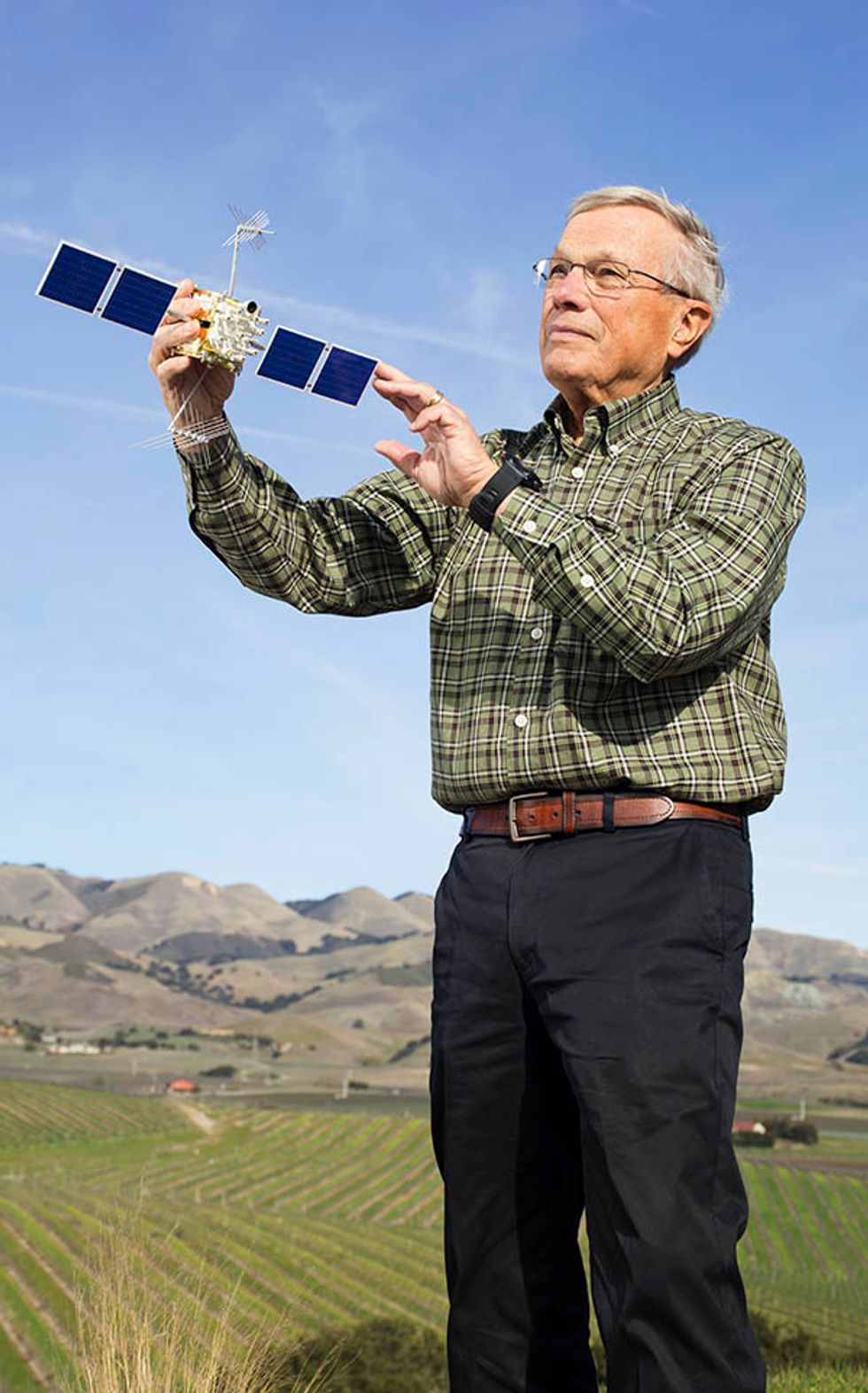 GPS On Board: Brad Parkinson, with a model of the GPS IIF satellite, gazes across the farmland near his California home. He sometimes spots GPS-guided automated tractors at work in the fields.Photo: Gregg Segal
As Parkinson's knowledge of navigation and space systems grew, the seeds that became GPS were being planted by others. In 1960, the U.S. Navy began testing its Transit program, a satellite-based method of updating the inertial guidance systems used by submarines. Transit's system worked with as few as four satellites (though the constellation typically included more) in low polar orbits. Along with a network of ground stations, the satellites allowed slow-moving vessels to determine their longitude and latitude a few times a day with an accuracy of about 100 meters.
Ivan Getting, president of the Aerospace Corp., didn't think that was good enough. In 1962, he started campaigning for a three-dimensional satellite-positioning system that would be more accurate and always available. Getting told me some years ago that he promoted this vision to the presidential science advisor, the heads of the armed forces, and anyone else he thought could have influence, trying “to get the damn thing funded."
Getting's evangelism led to an Air Force–sponsored study of space-based navigation. The final report, by James Woodford and Hiroshi Nakamura, was published in 1966, although it remained classified until 1979. It laid out 12 main techniques, including the one that became GPS.
In 1972, Parkinson's path and satellite navigation's evolution collided. Parkinson had spent the previous year studying at the Naval War College, in Newport, R.I., and sailing whenever he could. Up next would likely be an assignment in the Pentagon.
Then he got a call from a colonel who was part of a group known as the Air Force's inertial guidance mafia. “This wasn't a black-hat organization," Parkinson explains, “just people who had gone through the MIT inertial guidance course who looked out for each other." The colonel recommended that if Parkinson wanted to build systems rather than just analyze them, he should join the Advanced Ballistic Reentry System (ABRES) program, in Los Angeles.
Parkinson, just promoted to colonel himself, took the advice and moved to Los Angeles. He'd been at ABRES a little over three months, working on advanced nose cones and other missile technology, when he was identified as a perfect fit to take over a satellite navigation program called 621B. Parkinson had the right qualifications, but he didn't want the job.
“The consensus was that the program was going nowhere, that it was absolutely dead," he says.
But it was a three-star general making the offer, Parkinson recalls, and you don't say no to a general—usually. Parkinson said he'd take the job if he could be named program manager. Anything less, he said, would have been a downward move and wouldn't have allowed him to control the program—“and the program was in deep trouble."
The general refused. “So I said, 'Then I don't volunteer,' " Parkinson recalls. “He wasn't used to brand-new colonels saying 'No' to him."
Parkinson walked out of the office—but he had barely gotten through the door, he says, when the general called him back. Parkinson got his title and took over 621B in mid-1973.
The 621B program aimed to create a satellite-based navigation system that would work almost anywhere in the world. The team had already developed much of the plan and wanted to demonstrate it using four satellites—not an inexpensive proposition.
Parkinson began by going through every piece of the proposal with his engineers.
“We were a little worried when he first came on," recalls Walter Melton, an engineer assigned to the project from the Aerospace Corp. “We heard that he was from the inertial mafia." The engineers were concerned that Parkinson would be biased against satellite navigation, which was considered a competitor to inertial navigation. “But after the first several weeks it became clear he understood and was a supporter."
In August 1973, Parkinson presented the proposal to the Defense Systems Acquisitions Review Council at the Pentagon. “I told all these generals and senior civilians sitting around a table what I was trying to do, and then they took a vote," he recalls. The vote was “No."
Malcolm Currie, then undersecretary of defense research and engineering, chaired that meeting. At the time, Currie was spending a lot of time near his home in the Los Angeles area, preparing to move his family to Washington, D.C. During one of Currie's Los Angeles trips, Parkinson gave him a one-on-one tutorial on satellite navigation that took up most of an afternoon.
Parkinson now thinks that afternoon was the reason satellite navigation didn't die after the “No" vote. Indeed, it made an ally of Currie, who quickly reminded Parkinson that the concept presented was merely one he had inherited, not developed himself.
Parkinson reported in an oral history that Currie told him, “Listen, you did a very, very nice job, but you and I know that this is not truly a joint program…. Go back, reconstitute it as a joint program, and bring it to me as quickly as you possibly can, and I am very, very certain that we are going to approve it."
Parkinson and his engineers worked over Labor Day weekend to develop a new architecture for their satellite-navigation system. They met at the Pentagon rather than in L.A., he says, “because too many people associated with the program were entrenched in old ideas." Gathering in offices that were vacant because of the holiday, Parkinson says, “We hammered out what we wanted to do, and we summarized it in seven pages."
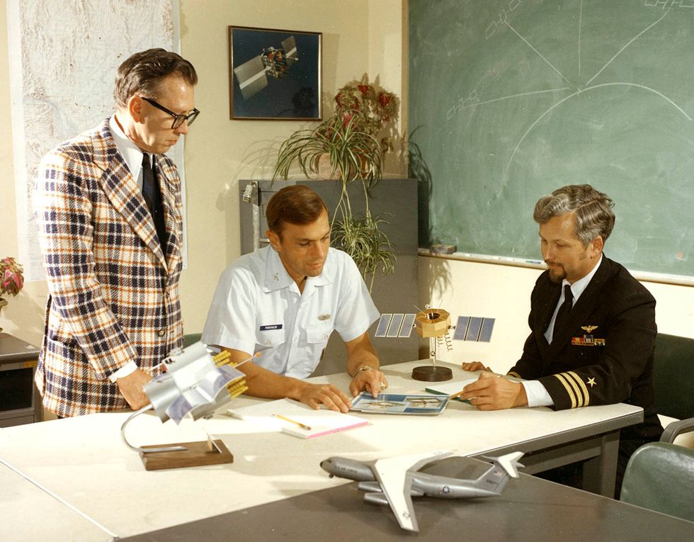 Talking Satellites: Brad Parkinson (center) discusses GPS navigation with the Aerospace Corp.'s Frank Butterfield (left) and the U.S. Navy's Bill Huston in the mid-1970s.Photo: U.S. Air Force
Parkinson recalls that the “Lonely Halls" meeting, as it came to be known, led to several key changes: The system's code-division-multiple-access (CDMA) radio signal was modified to include a civilian signal as well as the protected military signal; the orbits of the satellites were adjusted to reduce the number of satellites needed at the optimal altitude, considering the range of available launch vehicles; and the design embraced orbiting atomic clocks, which would free ground-based receivers from the need to keep precise time.
Parkinson says this third change was the most risky—atomic clocks that could handle space radiation did not yet exist. But he knew that Roger Easton at the Naval Research Laboratory was developing a space-qualified atomic clock as part of the Navy's Timation satellite navigation program—and he bet that some version of that clock would be available for the demonstration satellites.
This decision turned out to be critical for the cheap, small GPS receivers that consumers use today. If instead we all had to carry around superaccurate clocks, the receivers would be vastly more expensive and as large as a stack of dictionaries, Parkinson says. They also would require periodic synchronization to maintain accuracy. They certainly wouldn't have turned into a tiny package of electronics costing a fraction of a dollar, tucked inside every cellphone.
And Parkinson badly wanted consumers to use the new system. The mission of the project, in his view, was always twofold—extraordinary accuracy and affordability. He even hung a wooden plank above the entrance to the project's offices in Los Angeles to reinforce the message: “The mission of this office is to drop five bombs in the same hole and to build a cheap set that navigates—and don't you forget it."
Parkinson spent the months after the Lonely Halls meeting selling the proposal to Pentagon staff and decision-makers. He flew to Washington as often as twice a week, holding some 60 meetings in two months (he still has a list).
He parried every doubt: Yes, the signal would be powerful enough to be detected in the surrounding noise. Yes, the system's 10-meter accuracy was achievable. Yes, US $180 million would cover the constellation of four satellites and related ground equipment. (The final price was about $250 million, but that included two added satellites—not a horrible overrun, Parkinson says.)
“He was quite the salesman," says Melton, his colleague in the 621B program.
The Defense Council approved the proposal in December 1973. Parkinson led the program for three and a half years, until the first GPS satellite was up in space and initial tests verified that the system worked as designed.
Easton's atomic clock, it turns out, was not ready for that initial launch, but Parkinson had engineers at Rockwell International also working on a space-worthy atomic clock, which was ready. Parkinson still gives Easton credit.
“Easton convinced me that we could do it—and that made a heck of a difference," he says.
The full 24-satellite system became operational in 1995. The Russian GLONASS system, a similar project begun during the Soviet era, was also completed in 1995. Both the European Union's Galileo system and China's BeiDou system are expected to be completed in 2020.
Bradford W. Parkinson
 Photo: Gregg Segal
Date of birth: 16 February 1935
Birthplace: Madison, Wis.
Education: B.S. in general engineering, U.S. Naval Academy, 1957; M.A. in aeronautics and astronautics, Massachusetts Institute of Technology, 1961; Ph.D. in aeronautics and astronautics, Stanford University, 1966
Current position: Professor emeritus, recalled to active duty, Stanford University
First jobs: Supermarket carryout and stock boy, general laborer in construction, newspaper delivery
First tech job: Surveyor for construction projects
Most surprising job assignment: As an instructor at the Air Force Academy, flying 26 air combat missions to troubleshoot the electronics on the AC-130 gunship
Patents: Seven
Most recent book read: The Winter Fortress: The Epic Mission to Sabotage Hitler's Atomic Bomb, by Neal Bascomb
Favorite book: Tortilla Flat, by John Steinbeck
Favorite music: Classical, particularly Sergei Rachmaninoff, Edvard Grieg, and Ludwig van Beethoven
Favorite food: Spaghetti with meatballs
Favorite restaurant: Café Roma, San Luis Obispo, Calif.
How his spouse would describe him: Intense
After hours/leisure activity: These days, hiking, snowshoeing; in the past, sailing, skiing
Car: BMW Z4 and a GMC truck
Organizational memberships: IEEE, Institute of Navigation, Royal Institute of Navigation, SME, American Institute of Aeronautics and Astronautics
IEEE Medal of Honor: “For fundamental contributions to and leadership in developing the design and driving the early applications of the Global Positioning System"
Other major awards: ASME Medal, Charles Stark Draper Prize for Engineering, Marconi Prize, Royal Institute of Navigation's Gold Medal, Institute of Navigation's Thurlow Award
Parkinson retired in 1978 from the Air Force, but he didn't leave GPS behind. After several positions in industry (including vice president of Rockwell International's Space Systems Group and vice president at Intermetrics), he returned to Stanford in 1984, this time as a professor of aeronautics and astronautics. He immediately rejoined the orbiting gyroscope project, now called Gravity Probe B, as program manager and a coprincipal investigator; it successfully launched in 2004.
He also led a research group aimed at developing civilian applications for GPS technology. That work led to a robotic sailboat, the first GPS-guided landing of a commercial aircraft, and a system of ground stations that would improve the accuracy of GPS positioning by monitoring and correcting the satellite data. The last project evolved into the Federal Aviation Administration's Wide Area Augmentation System, which uses data from ground stations to improve GPS's accuracy by correcting errors in the signal caused, for example, by orbital drift and delays introduced by the atmosphere.
Parkinson's group also developed the application he is most passionate about today: automated tractors. He had kept automated tractors in his sights for some time; he listed the application as part of GPS's future in talks he gave as early as 1978.
It wasn't until around the 1990s, though, that he got his chance to push the technology along. At Stanford, he met with a representative from John Deere who was building ties between the company and universities. Parkinson demonstrated a GPS-guided self-driving golf cart.
“Think tractor," he told the visitor.
The Deere representative was skeptical that farmers would buy such a system, Parkinson recalls, but the company was eager to partner with Stanford and agreed to fund a development project.
“They sent us about $900,000 and two huge tractors," Parkinson says. A team of students spent several years developing the technology, first demonstrating a fully functional system in 1997.
Watching the rise of GPS-guided precision farming since then has been gratifying, he adds. Parkinson's home overlooks a farm, and he often walks in the fields, sometimes spotting, to his delight, a GPS-guided tractor at work. “The tractors pay for themselves in savings in fertilizer and in time."
“I think he likes the agricultural application because it brings home that GPS is for everyone," says Penina Axelrad, a former Ph.D. student of Parkinson's who is now a professor at the University of Colorado. “Now, of course, GPS is in everyone's smartphones, but that was an early application that everyone could value."
 Photo: Gregg Segal
Parkinson is now mostly retired, though he still has research projects running at Stanford.
He remains one of GPS's biggest fans—he has more than a dozen devices in his house and car that use GPS, including a watch he wears most of his waking hours.
“He just gets so excited when he sees cool things enabled by GPS," says Axelrad.
He is also quick to protect GPS when he feels that it's threatened. Right now, he sees a big threat coming from Ligado Networks, which aims to create a broadband wireless network using the 1,525- to 1,559-megahertz frequency band. This band is adjacent to the frequencies used by GPS, which are between 1,164 and 1,587 MHz, nestled among other bands essentially reserved for satellite communications. Ligado's band is reserved for Earth-to-satellite communications with some limited use of cell towers to help users connect to the network. Back in 2011, however, the U.S. Federal Communications Commission considered giving Ligado's predecessor, LightSquared, a conditional waiver to use the frequency band for unlimited ground-based communication. The GPS industry protested, showing data on interference, and in 2012 the waiver was pulled. But Ligado recently came back with a proposal for a lower-power system that it says won't interfere with GPS.
That proposal is still before the FCC. But testing by the Department of Transportation shows extensive interference, Parkinson says, particularly for the most accurate devices. He's been working on an editorial to alert the public to the danger of the proposal. Ligado aims to change the designation “of a quiet signal from space to powerful ground transmitters," he writes. “They would apparently use this to compete with the existing broadband companies. This country already has at least four broadband providers but has only one GPS."
Says Parkinson, “We endanger it at our peril."
This article appears in the May 2018 print issue as “GPS's Navigator in Chief."


