
![]()
One bone-chilling September morning, Clay Mitchell drives his combine harvester through a field of amber Iowa corn, elsewhere known as maize. Beneath him, the monstrous machine reaps and threshes the plants, winnows the grain from the chaff, and then blows the yellow kernels into a holding tank, where they pile up in mounds as lustrous as a leprechaun’s gold.
Thanks to this mechanization as well as to advances in seed genetics and chemical fertilizers, Mitchell and his neighbors can now wrest higher yields than any generation before them. They are some of the most successful corn producers in the United States, which grows about 40 percent of the world’s corn supply. But the big machines that extract this bounty have taken a toll on the land. Decades of tillage and compaction have weakened the soil, making it prone to heavy erosion from wind and rain.
Agronomists estimate that since large-scale farming began here about 150 years ago, Iowa has lost roughly half its topsoil. In the mid-19th century, the average farmer could dig a hole in his field and stick his arm in as deep as the elbow before he felt something other than black, nutrient-rich earth. Today, he’s lucky if he gets as far as his wrist. Recent measurements show that in many parts of the state, topsoil is washing away 10 to 50 times as fast as it can re-form. There is evidence that such rapid degradation is already depressing yields.
What’s happening in Iowa isn’t unique. Studies suggest that every year, one hectare of farmland anywhere on Earth loses on average 30 metric tons of soil—enough to fill a large shipping container. In some places, erosion has degraded farmland so severely that it has been abandoned. As the world’s population rises, farmers are faced with having to grow more crops on less soil. “Globally, we are on the fringe of not being able to meet the food demand that exists today,” says Richard Cruse, a professor of agronomy at Iowa State University.
Yet there may be reason for hope. A new tech-driven trend—some even say revolution—in agriculture is beginning to take hold in Iowa and in many parts of the world. Known as precision agriculture, the practice promises to reconcile mass food production with responsible land stewardship. It is perhaps best summed up by the oft-cited mantra “Doing the right thing, at the right place, at the right time, in the right way.”
The concept harks back to agriculture’s early days, when a farmer, working by hand, could give each plant the exact amount of nutrients, water, weeding, and pest killing it needed without disturbing the soil very much. That era is long gone. But now information and communications technologies are bringing it back. By adopting smart sensors and sophisticated mapping tools, farmers like Mitchell are aiming for the same level of meticulousness as their pick-and-hoe-wielding predecessors—on scales larger than was ever possible before.
Mitchell was one of the first commercial farmers to seriously pursue modern precision farming. Now 40 years old, he shares an engineer’s compulsion to continually improve the less-than-perfect. “When it comes to striving for absolute accuracy, Clay’s as dead-on as they get,” says Paul Schrimpf, a group editor at the trade publisher PrecisionAg.
Mitchell grew up on the same land he still farms with his father and uncle in eastern Iowa, where five generations of Mitchells have made their livelihoods since the 1870s. One of his earliest memories is of helping his father build a system of sensors and hardwired circuits for automating the flow of grain through a series of bins that dry and store the harvest. “As soon as I could turn a screwdriver, my dad would give me 10 cents for every relay I would wire up,” Clay recalls. Those old switches have since been replaced with programmable logic. Today, father and son control the bins through their smartphones.

As a young man, Mitchell took a break from farming to study biomedical engineering at Harvard University. But his heart was in Iowa. When he returned in 2000, he immediately began looking for ways to streamline his family’s operation.
The first challenge he took on was fine-tuning the process of planting and fertilizing seeds. Most of his neighbors would simply broadcast fertilizer over an entire field, till it into the ground, and then drop seeds in neat rows. But the Mitchells wanted to avoid both broadcasting, which wastes fertilizer on unseeded rows, and tilling, which intensifies erosion. So they bought a tractor attachment that cut grooves in the soil and injected fertilizer into the grooves. They figured they could then set seeds directly on top of each nutrient band.
They were wrong. They found it impossible to guide the planter along the same path as the fertilizer applicator. “You just couldn’t visually see where you drove before,” Mitchell says. He pondered solutions involving lasers and cameras. Then one day, he read that civil engineers were starting to use specialized navigation equipment to control earthwork machinery. “And I thought, ‘That’s perfect!’ ”
The product he discovered relies on signals from GPS satellites. But it is magnitudes more reliable than an off-the-shelf GPS unit. Using a signal-processing scheme known as real-time kinematics, or RTK, it can boost the accuracy of a GPS reading from about 3 meters to within just a few centimeters.
Unlike traditional GPS navigation, RTK requires the installation of a local base station, which Mitchell affixed to his parents’ old ham radio tower. He mounted a second receiver on his tractor’s roof. When he’s using the system, the fixed receiver measures the distances to several satellites using GPS signals, compares those to the real distances calculated from its known position, and then reports the errors to the tractor over a radio link. (It sends an update about every 50 milliseconds.) These correction codes enable the tractor to compute its location with greater certainty.
And RTK can refine this calculation even further. A typical GPS receiver determines distance by internally generating the same pseudorandom code that a satellite transmits. Then, by comparing the time shift between the two identical sequences, it calculates the satellite’s range. But because tens of microseconds pass between each bit, the receiver can resolve timing errors with only limited fidelity. RTK solves this problem by also tracking the waveform that carries the code, which cycles at a much higher frequency. This enables the receiver to estimate the start of each cycle with finer precision. Correction signals from the base station then help the receiver determine the exact number of wavelengths between it and the satellite.
Today, RTK and similar systems are most commonly used in agriculture for autosteering, which keeps a vehicle moving autonomously along a straight course. (Drivers must still make turns manually.) Autosteering has become so popular among farmers that tractor manufacturers now build it into all new models. But back then, few growers had heard of RTK. “People out here thought it was absurd,” Mitchell says. “Nobody saw an application for it.”
To Mitchell, RTK was the gateway to ever more sophisticated precision tools. He installed autosteering in his tractor and, with his father’s help, rigged up hydraulic steering and autocontrol in the planter and fertilizer applicator so that the attachments wouldn’t sway off course. He wired up a laptop computer inside the tractor’s cab, and he loaded it with software that maps his fields and keeps track of where he has been and what he has done. For instance, he can use the program to record where he has injected fertilizer and direct the planter to drop seeds in the same spots. The setup is so precise that it allows him to space each seed exactly between last season’s stalks, so that the new shoots won’t struggle to push through the debris.
Of all the Mitchells’ various cost-cutting, yield-boosting inventions, the capstone is their sprayer. Most farmers want to spritz their plants with precisely the amount of pesticides and herbicides that manufacturers recommend. They know that overtreating costs money and can pollute watersheds and damage crops. Undertreating, on the other hand, can breed chemicalresistant superweeds and pests by killing off all but the most hardy invaders. In practice, though, it’s easy to pass over parts of a field twice or to speed through turns, thereby double-dosing some plants while lightly dosing others.
Autosteering helps, but only some. Farmers still must manually steer their sprayers’ giant winglike booms—the Mitchells’ is 18 meters long—around field boundaries and waterways. These are places where spray rates vary wildly, simply because the boom moves faster on the outside of a turn than on the inside. “The errors are so great because the machinery doesn’t compensate,” Mitchell says.
The Mitchells’ sprayer is a John Deere model from 1998. Over the years, they have beefed it up it to do things that even today’s commercial sprayers can’t do. “You can’t just go out and buy this,” Mitchell says. One of the earliest modifications they made was to connect a programmable logic controller to valves that turn the spray nozzles on and off. They linked the controller to a display inside the cab and loaded the computer with digital maps of their fields. Now when Mitchell sprays a field, the RTK-equipped machine automatically clicks off any nozzles that pass over areas he has already sprayed or doesn’t want to hit.
The next challenge was making dose rates consistent along the radius of a turn. First the Mitchells replaced each nozzle with a set of three spouts of different sizes. This way, the machine could toggle among the three rates without having to increase pressure, which could cause droplets to drift. Then they stuck a potentiometer on the machine’s front axle, enabling the control system to calculate the relative speed of each section of the boom and vary its spray rates accordingly.
Yet Mitchell and his father felt the system could be even more exact. Because it relied on RTK readings to determine acceleration, it would switch the spray rate about one second after the sprayer’s speed had actually changed. “There was a lag,” Mitchell says. “So when you’d be speeding up or slowing down rapidly, like you do in small fields, you’d always be putting on the wrong rate.”
The Mitchells solved this problem by feeding data from the driver’s joystick accelerator to the logic controller. Then they programmed the system to anticipate speed changes based on the driver’s commands. So by the time the signals reached the drivetrain, the nozzles had already adjusted. “We’re now getting to the point where every square meter of the field gets the target rate,” Mitchell says.
Many of the precision innovations that the Mitchells have adopted or built themselves are no longer unique. “There was a time it seemed we were dragging everyone along,” Mitchell’s father, Wade, says. “Now we can’t keep up.”
“I don’t think we’re technologically limited. I think we’re human limited—not from an intellectual incapacity but from the will to adopt these things.”
Manufacturers of automated agricultural equipment now offer all sorts of bells and whistles, including various rate controllers and yield monitors. More and more they are taking advantage of wireless technology. John Deere, for example, is developing a suite of products under a strategy it calls FarmSight that let large-scale operators remotely monitor fleets of machines over a cellular network. “The human-technology interface hasn’t yet been mastered in agriculture,” says Tony Thelen, operations director of the company’s Intelligent Solutions Group. “Our efforts are to make data collection and decision support ‘walk-up’ easy.”
Yet worldwide, farmers like the Mitchells are still a minority. And persuading others to embrace precision management, particularly in the developing world, will take more than smarter tools, says Jerry Hatfield, laboratory director of the National Laboratory for Agriculture and the Environment. “I don’t think we’re technologically limited,” he says. “I think we’re human limited—not from an intellectual incapacity but from the will to adopt these things.”
“He is saying precision agriculture is just a theory,” Ezrin Mohd Husin translates for a Malaysian rice farmer who goes by the name Jailani. They stand on the bank of an irrigation canal overlooking Jailani’s paddy fields, where workers are busy “transplanting” little carpets of nursery-grown seedlings into the soaked earth. It is a steamy day in February, and Jailani wears knee-high rubber boots and a brimmed cotton hat. Ezrin, whose collared shirt is embroidered with the words Technology for Precision Agriculture, adds, “He is saying he is a farmer and he knows better than theory.”
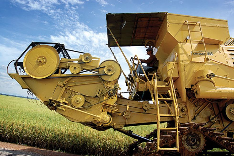
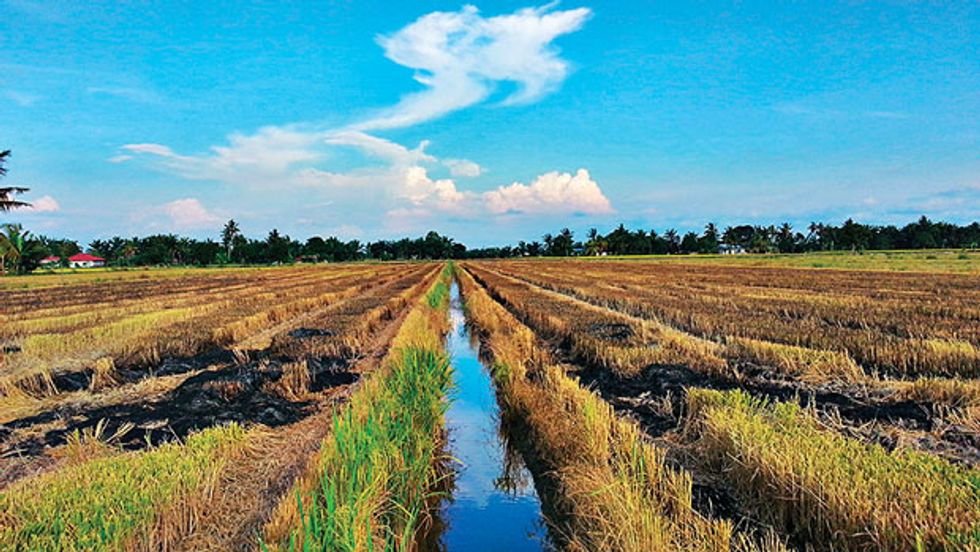
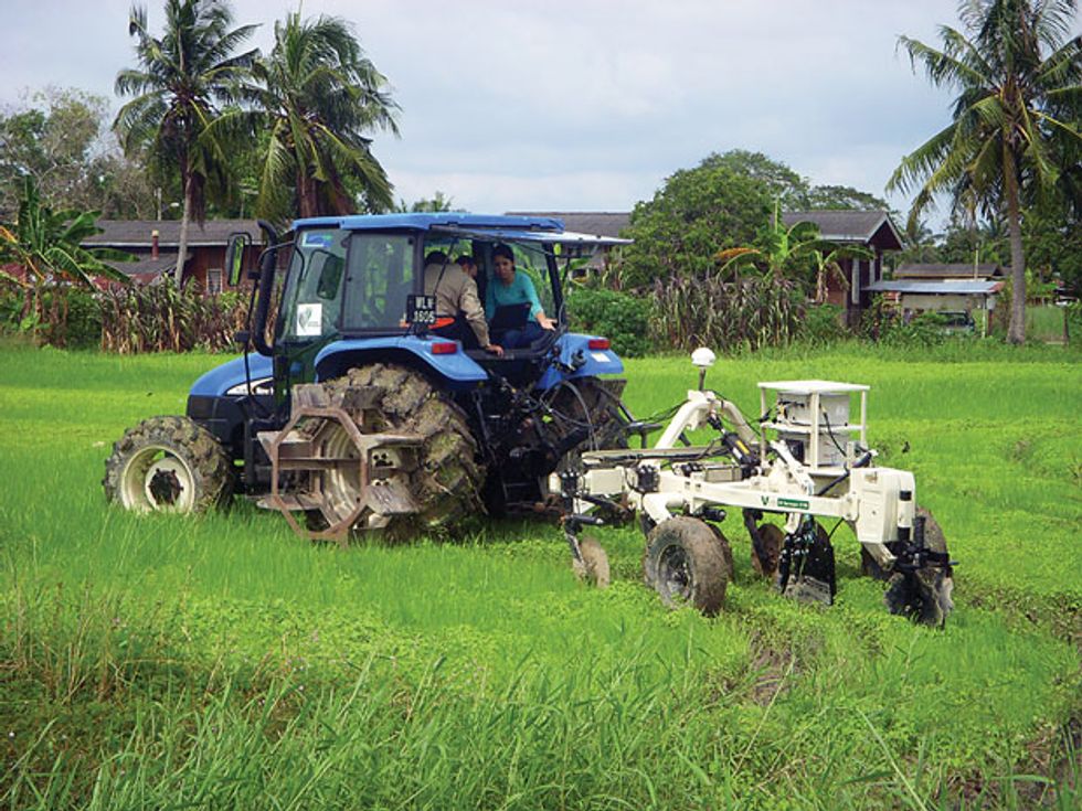 Far-Flung Adopters: In Malaysia, a harvester (top) works the rice fields (middle) of Tanjung Karang. The introduction of soil fertility sensors (bottom) is helping farmers there increase yields and reduce costs.Photos: Universiti Putra Malaysia (3)
Ezrin works for the Smart Farming Technology Research Centre at Universiti Putra Malaysia, a short drive south of the country’s capital of Kuala Lumpur. Its modest staff includes some of the few engineers in the world who have had success bringing precision practices to community farmers. In Malaysia, as in many developing nations, small family farms produce the bulk of the country’s staple crop. But for decades, Malaysian paddy farmers have grown only 70 percent of the rice Malaysians eat. “If grain prices rise globally, or if for any reason Thailand refused to export their rice, we are in trouble,” Ezrin says.
His fears are not merely hypothetical. In January 2008, a sudden spike in food and fuel prices triggered a worldwide cascade of rice hoarding. While exporters such as Egypt, India, and Thailand stockpiled their surpluses, Malaysia and other importers found themselves lacking. Not long after the “great rice crisis” ended that May, the Malaysian government set an ambitious goal to become wholly self-sufficient in rice by 2015.
In five years, though, the country has made virtually no progress toward reducing its dependency on foreign grain. Ezrin and his colleagues believe the reason is simply that the government hasn’t applied the right solution. “If you implement precision farming, it is possible to have full food security,” says Mohd Amin Mohd Soom, the center’s director.
Amin’s approach to precision agriculture is what’s often called variable rate. It differs from the kind of tactics the Mitchells use in that it does not assume every part of a field should be treated the same. Instead, farmers who practice this method take into account variations in soil composition and plant growth to determine exactly how much of something—water or fertilizer, say—each tiny piece needs.
Amin has so far focused on fertility because he believes it can make the biggest impact. Malaysian farmers typically apply chemical nutrients uniformly based on rates the government recommends, he says. His team has been trying to convince them they can get higher yields and save costs if they can figure out which areas should get more fertilizer and which ones should get less.
This isn’t an easy calculation. Farmers first need to be able to measure soil fertility quickly and cheaply, which means they can’t rely on laboratory tests. A simpler solution is to deploy electrical-conductivity sensors. For more than a century, geologists have used these sensors to chart Earth’s interior and to sniff out oil and gold. Around the mid-1990s, growers in the United States and Europe began borrowing the technique to survey their soils.
The most popular mapping system came from a Kansas company called Veris Technologies. It consists of a wheeled frame, which supports an array of platter-size steel disks. As a tractor pulls the cart through a field, the disks penetrate the soil. One pair of disks creates a voltage while a second pair measures how much the current drops as it flows through the ground. By using pairs of disks spaced at different intervals, farmers can gauge conductivity at various depths. And by equipping the system with satellite navigation, they can construct a detailed picture of soil variability—including differences in texture, water-holding capacity, and, to some extent, nutrient contents.
In 2004, Amin bought Malaysia’s first Veris machine with money from a government grant. The pilot study included only eight farmers, whose paddies surrounded the coastal community known as Tanjung Karang. Amin’s team mapped the electrical conductivity of the farmers’ fields and took several hundred soil samples over many seasons. Each season, the researchers used the results to model the relationship between conductivity and the amount of essential nutrients in the soil. Then they used the model to create color-coded maps showing farmers how best to distribute fertilizer. In some seasons, the model represented a dependence that was statistically significant. In other seasons it didn’t, but they used it anyway. “It’s not 100 percent accurate,” admits Aimrun Wayayok, a soil expert at the research center.
This unreliability is why some farmers, including the Mitchells, are skeptical of variable-rate methods. “Sprinkling a little bit less phosphorus on one part of the field and a little more on another doesn’t have a predictable benefit,” Mitchell argues. “It’s a very small Band-Aid.”
Aimrun disagrees. Electrical conductivity may not be the perfect predictor of soil fertility, he concedes, but it’s a start. And the maps have encouraged farmers to be more conscientious of how much fertilizer they use. In some cases, Aimrun says, they have cut their use by as much as 70 percent. “We are showing them that reducing fertilizer doesn’t necessarily reduce yield and sometimes increases it,” he says.

30 Metric Tons
Average yearly soil loss per hectare of farmland worldwide
Centimeter Precision
Level of accuracy enabled by state-of-the-art navigation technology
“Agriculture systems are very complex,” says John Schueller, an expert in precision farming at the University of Florida. “It is impossible to optimize completely. Even in Iowa, where farmers have access to the best technologies, they’re really not hitting absolute perfect conditions. So the question is: How close can you get? Usually doing something is better than doing nothing.”
Today, about 30 farmers in Tanjung Karang are enrolled in the center’s precision program. And in the nine years since the project began, the area has upped production from 4 metric tons per hectare (the national average) to more than 6 metric tons per hectare.
It is arguable that a big driver of this success has been broadband access. In 2008, the center oversaw the construction of an Internet café in Tanjung Karang. Here, Amin and his staff teach farmers in the community how to use computers and browse the Web. They’ve also created a custom website where the farmers can access fertility maps for their fields and track their activities throughout the growing season.
On this February day, the café is quiet and airy. Its picture windows frame undulating landscapes of tall green rice grass. A few teenagers sit at terminals Facebooking and playing video games. On a wall, someone has tacked a poster-size copy of a check for 50 000 Malaysian ringgits (about US $16 000). Printed on the bottom in Malay is the declaration “Best Paddy Field Management, Selangor AgroFest 2011.”
Eventually, a farmer named Aziz wanders into the café. He points to the check. “He says he is proud,” Ezrin translates. “He says previously, he protested precision farming. He could get 7 [metric] tons per hectare, which is very good. But then he tried precision farming and now he gets 9 tons—2 tons extra! And with half the fertilizer bags!”
Ezrin pauses. “See?” he says, grinning. “We are changing minds.”
For more about the author, see the Back Story, “A Culinary Quest in Malaysia.”