Earthquake Alarm
Impending earthquakes have been sending us warning signals—and people are starting to listen

Deep under Pakistan-administered Kashmir, rocks broke, faults slipped, and the earth shook with such violence on 8 October that more than 70 000 people died and more than 3 million were left homeless [see photo, "Devastated"]. But what happened in the weeks and days and hours leading up to that horrible event? Were there any signs that such devastation was coming? We think there were, but owing to a satellite malfunction we can’t say for sure.
How many lives could have been saved in that one event alone if we’d known of the earthquake 10 minutes in advance? An hour? A day?
Currently, predictions are vague at best. By studying historical earthquake records, monitoring the motion of the earth’s crust by satellite, and measuring with strain monitors below the earth’s surface, researchers can project a high probability of an earthquake in a certain area within about 30 years. But short-term earthquake forecasting just hasn’t worked.
Accurate short-term forecasts would save lives and enable businesses to recover sooner. With just a 10-minute warning, trains could move out of tunnels, and people could move to safer parts of buildings or flee unsafe buildings. With an hour’s warning, people could shut off the water and gas lines coming into their homes and move to safety. In industry, workers could shut down dangerous processes and back up critical data; those in potentially dangerous positions, such as refinery employees and high-rise construction workers, could evacuate. Local government officials could alert emergency-response personnel and move critical equipment and vehicles outdoors. With a day’s warning, people could collect their families and congregate in a safe location, bringing food, water, and fuel with them. Local and state governments could place emergency teams and equipment strategically and evacuate bridges and tunnels.
It seems that earthquakes should be predictable. After all, we can predict hurricanes and floods using detailed satellite imagery and sophisticated computer models. Using advanced Doppler radar, we can even tell minutes ahead of time that a tornado will form.
Accurate earthquake warnings are, at last, within reach. They will come not from the mechanical phenomena—measurements of the movement of the earth’s crust—that have been the focus of decades of study, but, rather, from electromagnetic phenomena. And, remarkably, these predictions will come from signals gathered not only at the earth’s surface but also far above it, in the ionosphere.
For decades, researchers have detected strange phenomena in the form of odd radio noise and eerie lights in the sky in the weeks, hours, and days preceding earthquakes. But only recently have experts started systematically monitoring those phenomena and correlating them to earthquakes.
A light or glow in the sky sometimes heralds a big earthquake. On 17 January 1995, for example, there were 23 reported sightings in Kobe, Japan, of a white, blue, or orange light extending some 200 meters in the air and spreading 1 to 8 kilometers across the ground. Hours later a 6.9-magnitude earthquake killed more than 5500 people. Sky watchers and geologists have documented similar lights before earthquakes elsewhere in Japan since the 1960s and in Canada in 1988.
Another sign of an impending quake is a disturbance in the ultralow frequency (ULF) radio band—1 hertz and below—noticed in the weeks and more dramatically in the hours before an earthquake. Researchers at Stanford University, in California, documented such signals before the 1989 Loma Prieta quake, which devastated the San Francisco Bay Area, demolishing houses, fracturing freeways, and killing 63 people.
Both the lights and the radio waves appear to be electromagnetic disturbances that happen when crystalline rocks are deformed—or even broken—by the slow grinding of the earth that occurs just before the dramatic slip that is an earthquake. Although a rock in its normal state is, of course, an insulator, this cracking creates tremendous electric currents in the ground, which travel to the surface and into the air.
The details of how the current is generated remain something of a mystery. One theory is that the deformation of the rock destabilizes its atoms, freeing a flood of electrons from their atomic bonds, and creating positively charged electron deficiencies, or holes.
One of us, Freund, working at NASA Ames Research Center in Mountain View, Calif., demonstrated through laboratory rock-crushing experiments that the sundering of oxygen-to-oxygen bonds in the minerals of a fracturing rock could produce holes. These holes manage to propagate through rock up toward the surface, while the electrons flow down into Earth’s hot mantle. The movement of these charges, measured at 300 meters per second in the lab, causes changes in the rock’s magnetic field that propagate to the surface.
Another theory is that the fracture of rock allows ionized groundwater thousands of meters below the surface to move into the cracks. The flow of this ionized water lowers the resistance of the rock, creating an efficient pathway for an electric current. However, some researchers doubt that water can migrate quickly enough into the rock to create large enough currents; for this theory to be correct, the water would have to move hundreds of meters per second.
Whatever the cause, the currents generated alter the magnetic field surrounding the earthquake zone. Because the frequencies of these magnetic field changes are so low—with wavelengths of about 30 000 kilometers—they can easily penetrate kilometers of solid rock and be detected at the surface. Signals at frequencies above a few hertz, by contrast, would rapidly be attenuated by the ground and lost.
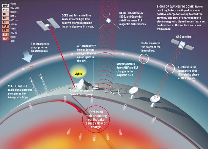
We can detect such electromagnetic effects in a number of ways [see illustration, "Signs of Quakes to Come”]. Earthquake forecasters can use ground-based sensors to monitor changes in the low-frequency magnetic field. They can also use these instruments to measure changes in the conductivity of air at the earth’s surface as charge congregates on rock outcroppings and ionizes the air.
Using satellites, forecasters can monitor noise levels at extremely low frequency (ELF)—below 300 Hz. They can also observe the infrared light that some researchers suspect is emitted when the positive holes migrate to the surface and then recombine with electrons.
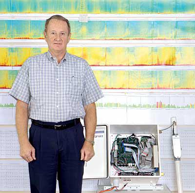
Scientists around the world are looking at all of these phenomena and their potential to predict earthquakes accurately and reliably. One group is at QuakeFinder, a Palo Alto, Calif.based company cofounded by one of us, Bleier, in 2000. QuakeFinder researchers have begun directly monitoring magnetic field changes through a network of ground-based stations, 60 so far, in California [see photo, "Earthquake Investigator”]. In 2003, the company joined forces with Stanford and Lockheed Martin Corp.’s Sunnyvale, Calif., center to launch an experimental satellite designed to remotely monitor magnetic changes. A larger, more sensitive satellite is in the design stages. QuakeFinder hopes to develop an operational earthquake warning system within the next decade.
The 1989 Loma Prieta earthquake near San Francisco sent out strong signals of magnetic disturbances fully two weeks before the 7.1-magnitude quake occurred. The idea that such signals existed was still a new one then, certainly not well enough accepted to justify a decision to issue a public warning.
We happen to have excellent data from that quake. Stanford professor Anthony C. Fraser-Smith had buried a device called a single-axis search-coil magnetometer to monitor the natural background ULF magnetic-field strength at about 7 km from what turned out to be the center of that quake. He selected this spot simply because it was in a quiet area, away from the rumblings of the Bay Area Rapid Transit trains and other man-made ULF noise. He monitored a range of frequencies from 0.01 to 10 Hz, essentially, the ULF band and the lower part of the ELF band.
On 3 October, two weeks before the quake, Fraser-Smith’s sensors registered a huge jump in the ULF magnetic field at the 0.01-Hz frequency—about 20 times that of normal background noise at that frequency. Three hours before the quake, the 0.01-Hz signal jumped to 60 times normal. Elevated ULF signals continued for several months after the quake, a period rife with aftershocks, and then they disappeared.
The Loma Prieta quake was a stunning confirmation of the value of ULF signals in predicting earthquakes. This validation of the theory prompted Bleier to establish a network of earthquake sensors in the Bay Area, an effort that grew into QuakeFinder.
Other researchers around the world who monitored changes in the magnetic field at ULF frequencies had noticed similar, but not as extreme, changes prior to other events. These observations occurred shortly before a 6.9-magnitude quake in Spitak, Armenia, in December 1988 and before a devastating 8.0-magnitude earthquake in Guam in August 1993.
Author Bleier recorded spikes of activity, four to five times normal size, in the 0.2- to 0.9-Hz range for 9 hours before a 6.0-magnitude earthquake in Parkfield, Calif., on 28 September 2003. Solar storms sometimes cause ripples in the magnetic field at those frequencies, but there had been no appreciable solar activity for six days prior to the quake.
In Taiwan, sensors that continuously monitor Earth’s normal magnetic field registered unusually large disturbances in a normally quiet signal pattern shortly before the 21 September 1999 Chi-Chi, Taiwan, earthquake, which measured 7.7. Using data from two sensors, one close to the epicenter, and one many kilometers away, researchers were able to screen out the background noise by subtracting one signal from the other, leaving only the magnetic field noise created by the imminent earthquake. Two teams, one in Taiwan and one in the United States, calculated that the currents required to generate those magnetic-field disturbances were between 1 million and 100 million amperes.
Besides detecting magnetic-field disturbances, ground-based sensors can record changes in the conductivity of the air over the quake zone caused by current welling up from the ground. These sensors can vary in form, but those we use are made from two 15-centimeter by 15-cm steel plates locked into position about 1 cm apart. A 50-volt dc battery charges one plate; the other is grounded. A resistor and voltmeter between the battery and the first plate senses any flow of current.
Normally, the air gap between the plates acts as an insulator, and no current flows. If, however, there are charged particles in the air, a current begins to flow, creating a voltage drop across the resistor that registers with the voltmeter. The currents created in this way are not large—on the order of millivolts—but are detectable.
Last year QuakeFinder installed 25 ELF detectors with such air- conductivity sensors in California’s Mojave Desert to determine if increased air conductivity actually precedes earthquakes and contributes to the formation of the so-called earthquake lights [see photo "Mysterious Lights”]. But to date, no large earthquakes have struck near these sensors, so no data are available yet.
Ground-based sensors are not the only mechanisms for monitoring the signals given off by impending earthquakes. Above the ground, satellite-based instruments are picking up interesting patterns in low-frequency signals and detecting other oddities.
In 1989, after the devastating earthquake in Armenia, a Soviet Cosmos satellite observed ELF-frequency disturbances whenever it passed over a region slightly south of the epicenter. The activity persisted up to a month after the quake. Unfortunately, no data were gathered just prior to the initial quake. In 2003, the U.S. satellite QuakeSat detected a series of ELF bursts two months before and several weeks after a 22 December, 6.5-magnitude earthquake in San Simeon, Calif.
In June 2004, a multinational consortium lead by the French government launched a new earthquake detection satellite called DEMETER (for Detection of Electro-Magnetic Emissions Transmitted from Earthquake Regions). DEMETER, much more sensitive than earlier satellites, has already detected some unusual increases in ion density and ELF disturbances above large quakes around the world. Unfortunately, the satellite was malfunctioning in the days before October’s temblor in Kashmir. Because the project is so new, researchers are still working on the tools for processing DEMETER’s data. Its backers are expecting more detailed analyses to be available this month.
Infrared radiation detected by satellites may also prove to be a warning sign of earthquakes to come. Researchers in China reported several instances during the past two decades of satellite-based instruments registering an infrared signature consistent with a jump of 4 to 5 oC before some earthquakes. Sensors in NASA’s Terra Earth Observing System satellite registered what NASA called a “thermal anomaly” on 21 January 2001 in Gujarat, India, just five days before a 7.7-magnitude quake there; the anomaly was gone a few days after the quake [see satellite images, "Warm Before the Storm”]. In both cases, researchers believe, these sensors may have detected an infrared luminescence generated by the recombination of electrons and holes, not a real temperature increase.
Even the existing Global Positioning System may serve as part of an earthquake warning system. Sometimes the charged particles generated under the ground in the days and weeks before an earthquake change the total electron content of the ionosphere—a region of the atmosphere above about 70 km, containing charged particles. If the ground is full of positively charged holes, it would attract electrons from the ionosphere, decreasing the airborne electron concentration over an area as much as 100 km in diameter and pulling the ionosphere closer to Earth. This change in electron content can be detected by alterations in the behavior of GPS navigation and other radio signals. Each GPS satellite transmits two signals. The relative phase difference between the two signals when they reach a receiver changes, depending on the electron content of the ionosphere, so tracking these phase changes at a stationary receiver allows researchers to monitor changes in the ionosphere.
Researchers in Taiwan monitored 144 earthquakes between 1997 and 1999, and they found that for those registering 6.0 and higher the electron content of the ionosphere changed significantly one to six days before the earthquakes.
Earthquake forecasters can also watch for changes in the ionosphere by monitoring very-low-frequency (3- to 30-kilohertz) and high-frequency (3- to 30-megahertz) radio transmissions. The strength of a radio signal at a receiver station changes with the diurnal cycle: it is greater at night than in daylight, as anyone who listens to late-night radio from far-off stations knows. The altitude of the ionosphere, which moves lower as the positive holes migrate to the surface, also has an effect on radio signals; the lower the ionosphere, the stronger the signals. So at dawn on an earthquake day, a curve drawn to represent the drop-off in radio signal strength will appear markedly different from the normal curve for that signal at that location.
The connection between large earthquakes and electromagnetic phenomena in the ground and in the ionosphere is becoming increasingly solid. Researchers in many countries, including China, France, Greece, Italy, Japan, Taiwan, and the United States, are now contributing to the data by monitoring known earthquake zones.
Using these phenomena for earthquake prediction will take a combination of satellite and ground-based sensors. Satellites can cover most of the planet, but at ELF frequencies signal sources are hard to pinpoint. Ground-based monitors have smaller detection ranges, up to 50 km, depending on the sensitivity of the magnetometer and the size of the quake, but are far more precise. With a network of such sensors, forecasters looking at the amplitude of signals received at each sensor might be able to locate a quake within 10 to 20 km. This means that, for an area as large as California, accurate earthquake detection might require that forecasters distribute 200 to 300 magnetic-field and air-conductivity sensors on the ground.
QuakeFinder and other groups are trying to get funding to integrate space- and ground-based sensors to detect all these precursor signals—electronically detected ELF and ULF magnetic-field changes, ionospheric changes, infrared luminescence, and air-conductivity changes—along with traditional mechanical and GPS monitoring of movements of the earth’s crust. With such a broad range of phenomena being monitored, spikes registered by different monitors detecting different types of signals would make forecasts more reliable. Forecasters may then be able to issue graduated warnings within weeks, days, and hours, declaring increasing threat levels as the evidence from different sensors begins pointing in the same direction.
Useful as such an earthquake warnin g system would be, we’re not ready to deploy one yet. For one thing, the scientific underpinnings of the phenomena need to be better understood before public officials and others have confidence in the data. On this front, author Freund has been investigating the theory that currents are generated by breaking oxygen-to-oxygen bonds in rocks under stress. He has experimented with various rock samples, demonstrating at the laboratory scale that cracking rock can produce positive charges, which, on a geophysical scale, could form significant ground currents and infrared emissions. Other rock-crushing experiments are under way in Japan and Russia. In Mexico, meanwhile, researchers are focusing on understanding the related changes in the ionosphere.
A working prediction system won’t come cheaply, but it’s nothing compared with the loss of life and the billions of dollars in damage that earthquakes can cause. The 200 to 300 ground-based sensors necessary to blanket California alone will cost $5 million to $10 million. A dedicated satellite with magnetic, infrared, and other sensors would cost $10 million to $15 million to build and launch.
Meanwhile, a few technical challenges remain to be solved. At satellite altitudes, space itself is full of noise, compromising the data gathered. The data must be digitally processed with filters and pattern-matching software, still being refined. And down on the ground, man-made noise fills the electromagnetic spectrum. Researchers are attempting to use differential processing of two distant sensors to reduce or eliminate such interference.
We expect these problems, both technical and financial, to be worked out within the next 10 years. Then governments in active earthquake areas such as California, China, Japan, Russia, and Taiwan could install warning systems as early as 2015, saving lives and minimizing the chaos of earthquakes.
About the Authors
Tom Bleier is CEO of QuakeFinder, in Palo Alto, Calif. He previously spent 37 years developing, building, and testing defense and commercial satellites and ground-control systems, most recently for Stellar Solutions Inc., a satellite-systems engineering company, also in Palo Alto.
Friedemann Freund is a senior researcher at NASA Ames Research Center, in Mountain View, Calif., and is also a professor in the physics department of San Jose State University, in California. His research focuses on how stress can cause electric current in rocks.
To Probe Further
QuakeFinder’s earthquake forecasting research, using ground-based and satellite-based electromagnetic monitoring techniques, is described at https://www.quakefinder.com.
Electromagnetic signals created by the fracturing of rocks before earthquakes are analyzed at https://science.nasa.gov/headlines/y2003/11aug_earthquakes.htm.
France’s DEMETER satellite’s monitoring of earthquake signals is discussed at https://smsc.cnes.fr/DEMETER/GP_actualite.htm.