In August 1479, a Franco-Portuguese fleet attacked a Genoese merchant convoy just off Cape St. Vincent, the southwest tip of the Iberian Peninsula. Three Genoese ships went down, leaving one wounded, almost-twenty-five-year-old sailor-adventurer adrift clutching an oar. He swam ashore at Lagos, Portugal, to find himself in the pilot house of the Age of Navigation.
And so the Genoan castaway Christopher Columbus started to soak up the high technology of his time, learning math, celestial navigation, shipbuilding, Latin…and map-making, the great enabling technology of the epoch. In short order, Columbus and his brother, Bartholomew, started (probably) a chart-making business in Lisbon, an enterprise that put him in touch with information and ideas from all of Europe. It was an information age, and the information was generating huge discoveries and massive fortunes—like those produced by the high tech and biotechnology booms of our own time.
So today we’re dipping back into Samuel Eliot Morison’s wonderful Admiral of the Ocean Sea (with the combinatorial publication date of 1942) for a look at how measurement—or, more particularly, mismeasurement—fueled the explorer’s conviction that he could reach the Indies by sailing west across the Atlantic. His certainty, rooted in some of his age’s best measurements, technologies, and calculations, was undermined by the entrepreneur’s hallmark character trait: When faced with several possible values for a key variable, Columbus would invariably choose the most optimistic.
We thus owe the great 1492 Enterprise of the Indies to three serious measurement errors.
Washington Irving’s overly imaginative A History of the Life and Voyages of Christopher Columbus notwithstanding, it was widely known by the 15th Century that the Earth is spherical. The question was, how big is the sphere? In 200 BCE, after all, Eratosthenes calculated the circumference of the earth to within one percent of its actual girth. He figured that one degree of latitude was equal to 59.5 nautical miles.
In making his own calculation, however, Columbus preferred the values given by the medieval Persian geographer, Abu al Abbas Ahmad ibn Muhammad ibn Kathir al-Farghani (a.k.a. Alfraganus): one degree (at the equator) is equal to 56.67 miles. That was Columbus’s first error, which he compounded with a second: he assumed that the Persian was using the 4 856-foot Roman mile; in fact, Alfraganus meant the 7 091-foot Arabic mile. (This is, of course, the sort of confusion of units that sent the Mars Climate Orbiter into its terminal swan dive in September 1999.)
Taken together, the two miscalculations effectively reduced the planetary waistline to 16,305 nautical miles, down from the actual 21,600 or so, an error of 25 percent.
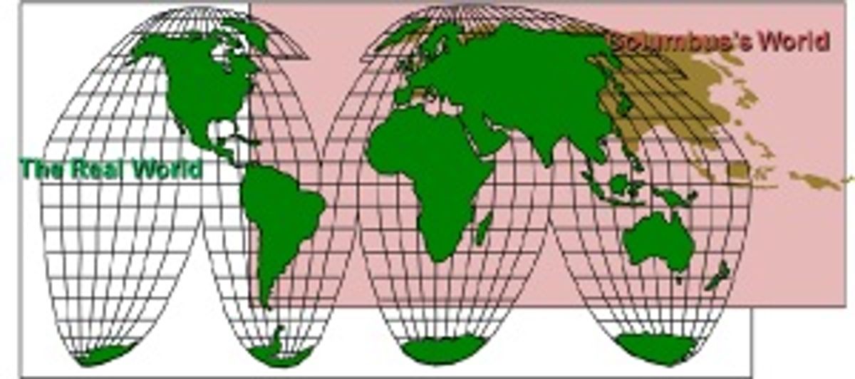
And then there was the third error. “Not content with whittling down the degree by 25 percent,” Morison writes, “Columbus stretched out Asia eastward until Japan almost kissed the Azores.” Through a complicated chain of reasoning that mixed Ptolemy, Marinus of Tyre, and Marco Polo with some “corrections” of his own, Columbus calculated that he would find Japan at 85º west longitude (rather than 140° east)—moving it more than 8,000 miles closer to Cape St. Vincent.
All in all, he figured, the Indies were just 68 degrees west of the Canary Islands. Calculated travel distance: 3080 nautical miles. Actual distance from Tenerife to Jakarta: 7313 nautical miles. Margin of error: 58 percent.
“Of course,” Morison noted, Columbus's “calculation is not logical, but Columbus’s mind was not logical. He knew he could make it, and the figures had to fit.” Morison, an admiral himself, is full of admiration for Columbus’s skill as a practical navigator, capable of pinpoint landfalls on his returns to the New World. As a metrologist and theoretician, however, he failed to double-check his work.
Image: Douglas McCormick
Douglas McCormick is a freelance science writer and recovering entrepreneur. He has been chief editor of Nature Biotechnology, Pharmaceutical Technology, and Biotechniques.


